
What price do you pay for a cup of coffee ?
A cup of coffee at twilight, at peaceful alpine lake that is reflecting a mountain range which is shimmering in alpine glow? My price for such experience for 5 days was 49 miles and 9800ft. climb.
Although my attempt to complete John Muir Trail this year is foiled by wild forest fires, wilderness experience was amazing as always. I set out on August 16th 2015 with 12 days, 110 mile hiking plan to finish the trail from Muir Ranch Trail to Mt. Whitney and eventually to trailhead at Whitney Portal. Unfortunately I had to exit the trail on 4th day into the trip, as rest of the trail was impacted by Rough fire smoke. Reaching end of the trail is never my intention. My goal is to experience the journey and mountain scenery along the trail. More than the destination, I want to remember the journey. I do not want to walk the trail for the sake of “finishing” the trail. I’ll go back to the trail next year to experience rest of the trail.
Here is map that shows where the fire is burning vs. my route

I wanted to publish trail journal for entire JMT together, but since this trip is short, I publish it anyway. Here is my day to day journey…
Day 1
Vermillion Valley Resort hikers van picked me up from Fresno Hotel at 8:00AM. We picked up my wilderness permit on the way at Prather. Ranger briefed me on usual wilderness rules and wild fires. She told me that no fires are in my way and nothing that I need to be concerned about. After 3 hours of driving, van dropped me off at Florence lake at 11 AM. I was happy to be back at Florence. There is nothing but a small store that operates boat across Florence. Next boat was at 12:30PM. I gulped two ice cream bars as waited at the store. Once boat leaves the dock, it will be long before I can taste any thing yummy again. Two rangers came from other side of Florence. We had short chat and they left as their ride arrived. I crossed Florence and started the hike at 1PM to Muir Ranch.
Florence Lake is at 7300ft elevation. Trail climb 500 ft. immediately and flattens till Muir Ranch. I met a couple and JMT Yahoo group co-moderator John Ladd at Muir Ranch. I spent about an hour and took off for Piute Creek. Just another small elevation gain but it was nice 3 miles hike next to south fork of San Joaquin River and Mt. Henry
Here is an picture on the way

I crossed Piute Creek and entered into Kings Canyon National Park. I camped next to Piute Creek below Pavilion Dome.
Sunset illuminated Pavillion dome


Over all about 900 ft. elevation gain and 8.5 miles hiking today

Day 2
Broke camp at 10AM. Sun was harsh already. Predicted high was 100 degrees that day. Trail continued next to south fork of San Joaquin River, climbing very gradually.


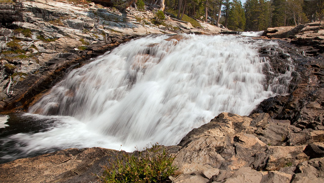
I followed San Joaquin until Evolution Valley, where Evolution creek drains into San Joaquin River. I left San Joaquin and followed Evolution creek upstream and started to climb up switch backs. It was intense. But Evolution Creek has numerous cascades made the effort worth.
Here are few Images


I crossed Evolution Creek before Evolution meadows. This creek crossing on JMT is considered dreadful in normal snow years. Lot of planning revolves around the creek crossing such that it is crossed early in the morning while water levels are low. California is under serve drought since last four years with worst/least snow fall last winter. So this so-called dreadful creek crossing was merely few inches above my ankles.
Here is the picture of the creek. You can search YouTube for Evolution creek crossing to see typical water levels of this creek.

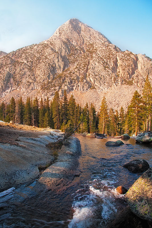
After few miles hiking, I reached McClure Meadows. It was so beautiful. I wanted to camp there. It’s great place to shoot sunset and sunrise. The meadow might see lot of wild flowers in early to mid July. It is worth paying a visit during that time. McClure attract more people and get crowed as well. 10 tents at one place is called crowed in wilderness. I did not stop at McClure and continued further about 2 miles and camped right at foothill of Mt. Hermit. It was great place.
Here are images of Day2 campsite (taken in the morning of Day3)

I hiked about 10 miles today with about 2000 ft. elevation gain.

Day 3
Broke camp at 9:10AM. It was a big day. I crossed Muir Pass and reached close to Big Pete meadows. Effective elevation gain was about 3100 ft. with 12 miles hike. As I left campsite, trail immediately started climbing towards Evolution Lake. Mt. Hermit and Evolution valley were in sight for some time.
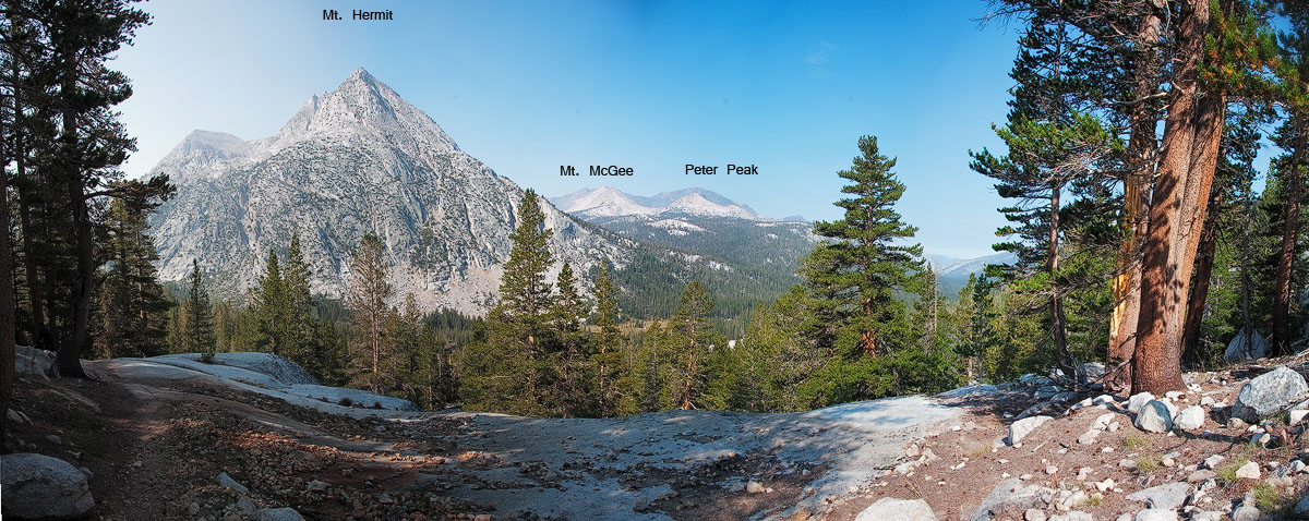
Eventually I crossed Evolution Lake, Sapphire Lakes. All the mountains in this region are named after scientists worked on Theory of Evolution (click on images to view larger)
.


I crossed Wanda and McDermand Lakes before reaching Muir Pass. Muir Pass is 11,955 ft. The pass is on saddle between Mt Solomans and Mt. Warlow. Sierra Club built a stone hut in 1931 and dedicated to memories of John Muir. It’s shelter for hiker who may stuck on the pass during bad weather. We cannot camp in the hut itself in fair weather conditions. I want to camp near the pass next time so that I can photograph Muir hut with Milky-way galaxy.


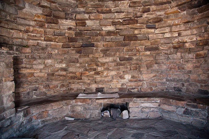

Sitting in front of the hut, you can see Evolution range and Black Giant in front yard. Mt. Solomons in backyard.

I spent about 45 minutes in the hut and started descent into Le Conte Canyon. I dropped down to Helen lake at 11,600ft. and things changed dramatically. I started to see and smell smoke strongly.

From Helen, I caught middle fork of Kings river and started descending into Le Conte Canyon. With in few minutes, I met a hiker coming in opposite direction. He delivered the bad news, “Rough fire is gaining ground, 0% contained so far and the trail all the way till south of Forester pass is under smoke”. He told that on ranger recommendation many of the south bound hikers exiting via Bishop pass. As I climbed down further, situation was very apparent to me. Mt. Langille was right next to the trail, but I could not see it. I came down as close as possible towards ranger station, so that I can get there quickly in the morning to assess the situation. I camped that night close to Big Pete Meadows. Night was miserable. My eyes were burning and smell made me wake up all night.
That day I hiked 12 miles with 3100ft. elevation gain

Day 4
Morning was much better. Smoke considerably reduced. Here is a view from my camp site.

While climbing down 4 miles to Le Conte Ranger station, I spoke to several hikers coming up from north. Everyone said it’s not worth going south any further. Ranger station is located at 8700 ft., where trail from South lake (bishop) joins JMT. Ranger told me exact same words that I have been hearing past couple of hours. Ranger posted this note on the trail.

Air was clean in the morning few hours until wind picks up and bring smoke. I could hike in those hours and take break rest of the day. But it defeats the purpose of being in the mountains. I cannot see and enjoy them in smoke. And with that pace I can not reach Wood Creek in two days to catch packer who is bringing my resupplies. Without them, I had to exit the trail from Kearsarge pass anyway.
Next steps become apparent to me. Trail from here to South lake is 12.8 miles with 3300 ft. elevation gain. It goes thru Dusy basin, over Bishop pass to South lake. Given the worst experience last night, I wanted to climb up as much as possible to escape the smoke. Dusy basin is familiar grounds to me. Kiran and me hiked this area two year ago via Bishop pass. We stopped at lower Dusy basin. But did not come down to Le Conte Canyon that time. Another long day, but climbed up all the way to Upper Dusy basin at 11,200 ft. Smoke persisted through out the trail, but not bad at upper basin.
I camped at upper Dusy basin lake.
Palisades are the first 14ers on the trail. I should have seen the full range on JMT. But from here, Mt. Agassiz, Mt. Winchell, Mt Thunderbolt and North Palisade should be visible. I can see Mt. Agassiz in haze, but rest of them are barely visible. Alpine glow on Palisades was great treat, despite of the smoke.


Night was cold and peaceful. Overall that day I hiked 11 miles with 2700 ft. elevation gain.

Day 5
Got up to clear skies and clean air. I could see Palisades clearly. I finished regular chores and started for Bishop pass.
With in an hour, I was on Bishop pass. Hakan suggested me over satellite communicator to leave the pack on pass and climb Mt. Agassiz. It looked tempting. It would be 1900ft. climb from the pass. First 3/4 on loose rock thru a gully and top 1/4 was on solid rock a class-2/class-3 climb. After reconsidering the situation, I dropped the idea. There were still lot of unknowns. I need a ride from south lake trailhead to Bishop. Don’t know how long it takes. Once I get to Bishop, I need to find one way rental car. If I get the car in time, need to find what road are open to get back other side of the mountains. So I dropped the idea and hurried down the pass.
On the way, I met Abraham. He has been in Sierras doing cross country for last 30 days. Hopping one lake to other and fishing. He is going back in for another 30days. We had long chat on his where about. Very interesting personality.
Small geology lesson. As you see Mt. Goode has cirque in below picture. It accumulate lot of snow durig winter. During thaw, water runs down the slopes and feed lakes. Northern slopes not exposed much to sun during summer, thus snow on northern slopes last longer. Over run from each lake at upper elevation drains in to slopes. If the flow encounter a basin, it creartes another lake and over flow from that lake drains into slopes again. It usually continues until water reaches a river.
You can see Sierra water shed pretty clearly as you hike JMT. Below picture shows South fork of Bishop creek starts at Bishop lakes (no lake above it) and drains into Saddlerock Lake. Next image shows Spearhead lake that is below Saddlerock. Spearhead lake drains into Long lake, which eventually drains water into South Lake. Bishop creek has three forks. South fork, Middle fork and North fork. Like south fork that drains into South lake eventually , middle fork drains into Lake Sabrina and north fork drains into North lake. All three lake outlets created Bishop creek. Bishop creek altimately flows into Owens River. This is typical water shed configuration in Sierras.


Here is 5th day trail

As soon as I reached South Lake Trail head parking lot, I saw someone pulling out their SUV. I asked for lift and they accepted. They just finished their hike from Onion valley to South Lake. That whole stretch was under smoke. They told me their horrible experience.
I could not find any rental car in Bishop or any town around. I stayed that night in Bishop in Hotel and rented one way car from Reno. Next day at 7:30AM, I took Bus from Bishop to Reno airport (Eastern Sierra Transit) and picked my car at Reno Airport and drove back home.
That concludes my attempt to hike JMT this year. Except the smoke part, this part of Sierras is wonderful.
Now that I landed back in civilization, I need to be more alert as probability of dangers increased 1000 times than that in wilderness.
Over all this trip statistics are 5 days, 49 miles with about 9800 ft. elevation gain.
Click here to download KML data that you can upload to Google Earth and explore the trail online in detail.
Here is the overview of the trail that I traveled in this trip

“I saw the mountains, with grey veils down and songs seized
Mourning for burning forest and fallen comrades
Among the mountains, I stood with my arms wide open
Not as an emancipator of their anguish, but with empathy and understanding
Among the mountains, I stood with grievances
Not seeking a culprit, but solutions for animosities against nature
Among the mountains, I stood in guilt and self incriminated
Remorse itself is not a solution, but need your actions”
~ Swamy Lokanadham
I thank thousands of firefighters battling with Rough fire over last few weeks.
Happy Hiking
~ Swamy

