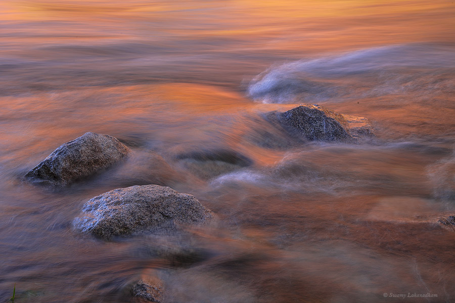
Reached Kathmandu airport (Elevation: 4390ft) by 6:30am. Airport was bustling with hiker and climbers. Very exhilarating scene with backpacks, duffle bags, hiking boots everywhere.
Our Summit airlines flight to Lukla supposed to takeoff at 7AM. It’s 18 seat small plane go to and fro between Kathmandu and Lukla through out the day transporting Everest hikers and climbers. Due weather, flight delayed until 10am. At 10am, after taxing all the way to runway, flight canceled due to high winds at Lukla. we had to come back and de-plane at terminal. Small planes like this cannot withstand strong winds. We had no choice than to wait and hope situation get better later in the day.
Wait was ended at 3PM with all flights to Lukla cancelled for the day. There were two options left for us, either to hire chopper or drive to Ramachhap (4 hours drive) and take early morning flight to Lukla. Flights from Ramachhap has better chances than Kathmandu as all flights to Lukla booked for several days.
Chopper can fly in the windy situations. But chopper are all booked for the day. Don’t want to take another chance with Kathmandu-Lukla. So we decided to drive to Ramachhap and take early morning flight to Lukla from there.
The trek started jittery… but that’s the deal with mountains…unpredictable weather. We will have to push little bit harder tomorrow to get all the way to Namche Bazaar to gain back one day. More later
Day2 (March 20th 2024)
Sometimes, simple and easy task/achievement/milestone can become difficult, arduous and
complicated due to things that may not be in our control or due to unforeseen circumstances. What’s important is to focus on objectives and push forward to achieve goals instead of wasting time on thinking why it’s happened to you. Reaching EBC trail, a simple 30min flight to Lukla turned out be challenging in same way to me. Sitting ducks and waiting for things to get better for you is not my way. I weigh more to certainty than unknown, even if the path is harder.
Our flight supposed to be at 7:30 from Ramachhap airport in Manthali. I woke up for loud bangs on door at 6am. Summit airlines representative waking up everyone to get ready for the flight…only happens in Nepal 😀
We reached small village hotel last night at 9. Hotel is right opposite to airport. We walked in with luggage into chaotic departure room.
There are 24 passengers and need two flights ( flights from Manthali are even smaller). Because it’s only 15 min flight, whenever opportunity knocks, flights will take off more often from here than Kathmandu. Our waiting game started from 6:30am and ended by 10am with heavy rain. Both flights and helicopters are grounded. Weather situation forecast to be bad until Friday.
Me and Mangal ( my guide) started exploring other avenues. We can’t rely on possibility of weather clearing on Friday. Best possible way is to hire a local jeep and travel Salleri, 6 hour, 170 KM road trip on mountains and stay for the night. Next day hire local 4-wheel drive vehicle to cross 80 KM off-road trail to connect with original trail Edmund Hillary and Tenzing Norgay at Puiyan ( they reached 7th day to Puiyan) (Paiya our actual destination). Our estimated was that it takes 6 hours. If we start at 4, we reach 10 AM and start our hike to Phakding. This puts us 2 days behind schedule.
Since both Salleri and Paiya jeep trips cost high, we started recruiting team to join us. Trijit, software engineer from Calcutta is quick to join us. He asked his guide to join him at Phakding instead of Lukla. Deb and Zoya, couple from Calcutta are convinced as well. They needed to hire a porter in Lukla, but they decided to check their luck in Paiya. Jenny, French girl, living in Pune joined with her guide Raj. We already over recruited at that point. We started at 10:30am and reached Salleri by 4:30PM. Entire 6 hours was raining and foggy.
Tea break somewhere on the way
I observed the property level in Nepal in my two days of rural Nepal road trips. It’s very saddening to such a beautiful country.
This is not part of off-roading. It’s one of the main roads
Stayed in nice Everest hotel in Phaplu. “Nice” is of course relative. Had good time relaxing and mingling with hikers and climbers from across the world.
While the world is grappling with the pandemic and is inundated in sorrow and suffering from bereavement, far beyond the storm clouds, rays of hope shine in the form of unity of humanity beyond boundaries of countries, race and religion. As the war of worlds emerges, human spirit, intellect, and ingenuity are our defenses. The wheels of the world might be slowing down, but we will never let them halt. As always, we will be victorious. Many thanks to our front-line forces… our medical and bio-research community working hard in the fight against COVID-19.
This situation temporarily prevents us from going to the mountains, but nothing can stop your wandering mind. While I can’t go out and take photographs, here I present my latest painting. This is a reproduction of my favorite painting (Sierra Morning) by one of my all-time favorite painters from the 19th century. It’s an interesting story on how I came cross this painting and how I found Albert Bierstadt.
About 16 months ago, one winter night, I planned to stay in my log-cabin and continue to work on the cabin next day. The only power source, a temporary electric power outlet installed on a pole, gave up on me that rainy night, forcing me to get out and find a shelter outside (hotel). In that hotel lobby, I found a cheap photo print of Sierra Morning (I didn’t know the title of the painting at that time). Despite the appearance of photo print with the glares all over from the cheap glass on the frame, I instantly realized what the original would look like. I took picture with my phone. There was no title of the painting nor the painter’s name on the print. I came home and searched online with the hope that such a talented artist and masterpiece would never be neglected by the world, and that I’d surely find them online. My only information was that one picture of the painting from my phone. With some struggle, purely based on subject, environment and intent that painting was trying to convey, I picked few paintings came up in the Google search. I didn’t see Sierra Morning among them. However, most of them happened to be painted by an American German painter of 19th century, Albert Bierstadt. I felt Sierra Morning must be his work. I was so inspired and started researching his work. Then I found, Sierra Morning at Gilcrease Museum (located in Oklahoma) website. For legal reasons, I may not be able to post the photograph of original here, but you can surely find it online with title and artist name. This is classic example of having a unique style in your art, that works as an invisible signature and identifies you automatically. It sets you apart from others and gives identity. Your work speaks for you. I had similar experience recently at La Sagrada Familia, Barcelona, Spain. I hope to talk about it sometime.
Ever since I saw that painting in that hotel, I wanted to paint it so that I can learn the techniques used. No way, I can imagine, getting any where close to the original… but I could learn immensely by trying it. When it comes to painting, I’m still learning to walk. Attempting to paint Sierra Morning is more than a marathon. This painting is my 4th attempt in last 16 months. After spending nearly 80 hours (48 on last one), I think, I have something presentable. I was able to capture some the elements in the painting that I wanted…like lighting and atmosphere to some extent . I obviously learned a ton from this experience.
Inspired by Albert Bierstadt painting “Sierra Morning” (3ft x2ft, Oil on Canvas)
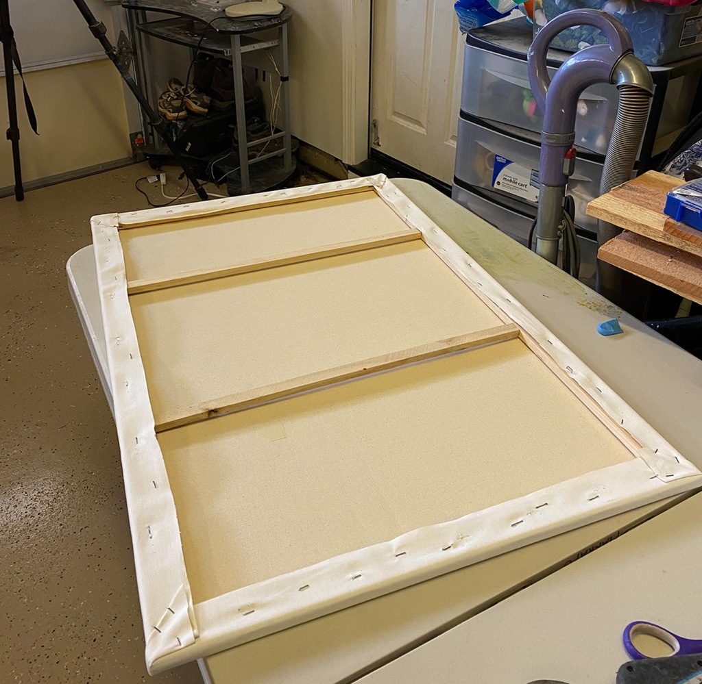
After my first two attempts, I almost gave up on this. After I came back from Spain in December (2019), inspired by Spain old master of the painting (from Del Prado Museum in Madrid), I decided to give another try. Unlike my previous attempts, I wanted to do large format canvases. So I built an easel that can support 5 ft x 5 ft canvas.
When I started looking for large format canvases, I found that the ready made canvases have very flimsy frames. I was afraid that they won’t last longer. So I decided to build my own frames and stretch my own canvas.
It’s an easy process and gives you lot of control on customer aspect ratios of your painting and adding quality base on canvas etc.
Looking back at the work, I made several things on my own, including learning to paint, however, the essence of the painting or intellectual property (IP, as we call in our line of work) is the composition of the painting, which is not mine at all. So this work may always be called an attempt to reproduce Albert Bierstadt’s Sierra Morning…
Any information that you might want to know about any painting technique or building easel or canvas stretching, I’m happy to share information from this experience.
Stay home (I never thought I would ever say that) and Stay safe
Have you gazed on naked grandeur where there’s nothing else to gaze on,
Set pieces and drop-curtain scenes galore,
Big mountains heaved to heaven, which the blinding sunsets blazon,
Black canyons where the rapids rip and roar?
Have you swept the visioned valley with the green stream streaking through it,
Searched the Vastness for a something you have lost?
Have you strung your soul to silence? Then for God’s sake go and do it;
Hear the challenge, learn the lesson, pay the cost.
~ Robert William Service
Not for the God’s sake, but for my own sake, I finally kick started my backpacking ventures again after two years break. Last month, I went to Big Pine Lakes in John Muir Wilderness. I hiked up to third lake, but this trail has 7 beautiful lakes. Trail head is at 7820 ft located at Glacier lodge, which is about 11 miles on glacier lodge road from Big Pine town. Total hike is about 11 mile round trip up to third lake with ~2500 ft elevation gain.
Trail starts on paved road next to Big pine creek.
There are aspens and mountain birch on trail and on the banks of the creek, which change colors in falls. So it will be great spot for fall photography as well. You will pass first waterfalls with in few yards from the trail head.
Trail climbs through switchbacks right after the falls. End of the switch backs, trail splits into South fork and North fork. Follow North fork to Big Pine Lakes. Trail is shaded with Jeffery pine trees for first few miles. In about a mile, you will cross the creek over a bridge. Trail again splits into high meadow trail on the right and North fork on left. Take left to continue on trail long side of the creek.
In about 2.75 mile mark, you will come across a nice cabin. It was build in 1929 by an Hollywood actor Lon Chaney as wilderness getaway. It was a great idea and great location. Big Pine Creek flows right in front of the cabin. It wasn’t far from the trail head, yet surrounded by pines, mountains and creek that carry pure glacial waters. Great wilderness experience. Currently this cabin is owned by national forest services and interiors are closed for public.
Trail continue to climb. Just before 1st lake, trail splits again. Trail to Black lake goes onto right. Follow the trail to left and soon you will see the first lake. The turquoise green lake is strikingly beautiful. From this location, you can see Temple Crag, but I did not find a appealing composition (Frankly, not explored this lake much). I continued towards second lake. Second lake is not much further from there.
I spent about an hour searching for a perfect spot from where I want to shoot sunset and potentially milky way galaxy and setup my tent. I left my gear and scouted out to third lake. But I liked second lake much better.
From third lake, a trail goes to Palisade Glacier. From second lake, the glacier is about another 4 miles with 2000 ft more elevation again (~12000 ft.) . Palisade Glacier is the southern most glacier that survived till now in North America. For those who haven’t seen a glacier, this will be a great trip.
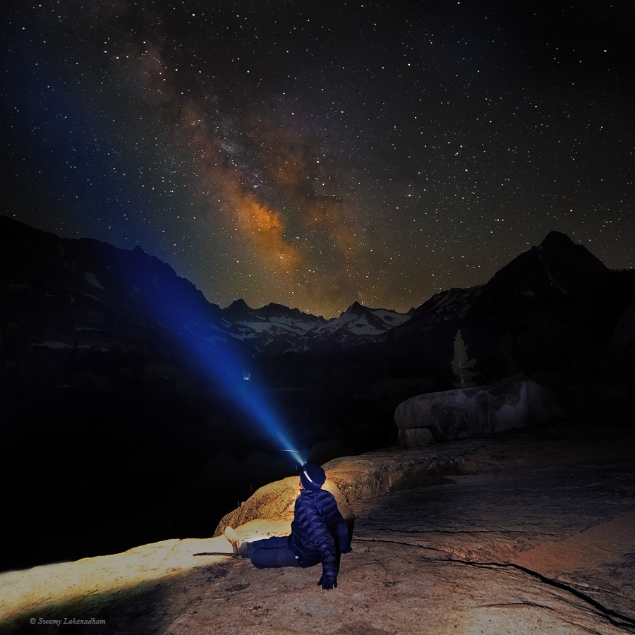
I shot night sky right from my camp. While I was shooting milky way, I saw someone flashing light from Temple Crag, saddle on the right side. I wasn’t sure, if a climber stuck there and signalling for help or camped intentionally. I know climber camp at third lake and climb Temple Crag in the day and comes back to the camp by evening. I felt dumb not knowing Morse code for SOS, if that’s what they were signaling . I was confused on how to react. Flash lights eventually died down. Fortunately, it wasn’t any emergency, I later checked. However, first thing that I did right after I reached home is to check Morse code. It’s dot-dot-dot dash-dash-dash dot-dot-dot. This trip was short, but the area is beautiful. Lakes reminded me lakes in Canadian Rockies. Hopefully, will get back here in the fall.
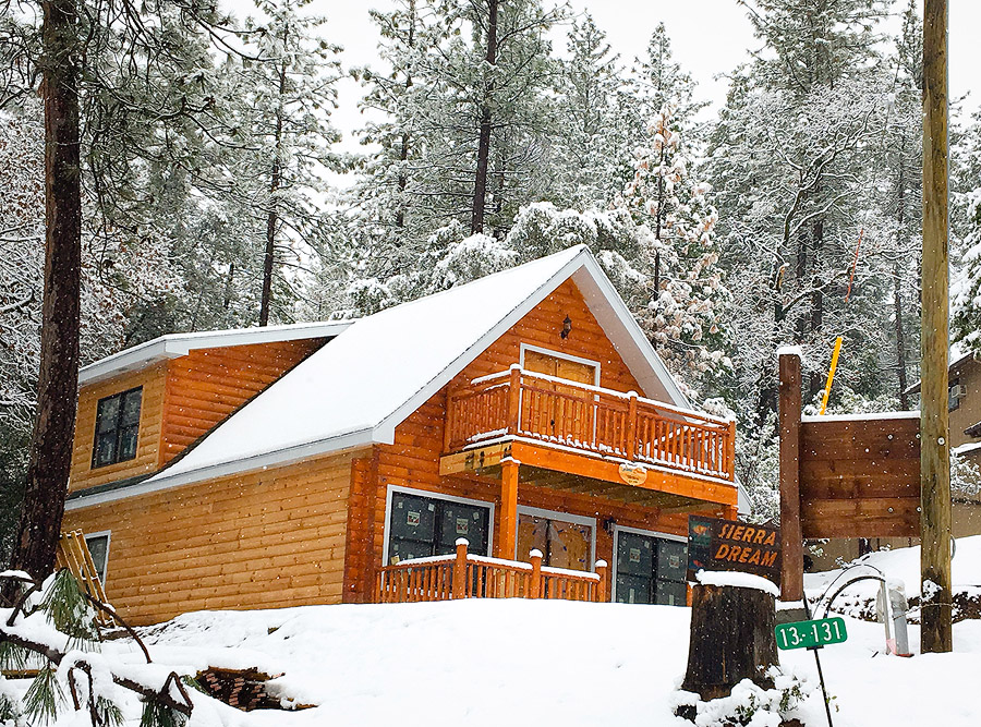
It’s been close to two years since I have written a blog post. Although I have had a couple of short trips and shooting opportunities, there was not much to share for the last couple of years. It was neither my detachment with wilderness nor developed disinterest in photography. In fact, it all started during my last backpacking trip (that I posted below) to 20 Lake Basin. During that trip prep, I saw nice cabins near Lundy Lake, just on the other side of Tioga Ridge from our trail. It has been a dream to have an off-grid mountain cabin, far from civilization, close to an alpine lake that one can reach only by hiking to; to stay for a couple of weeks in the cabin every year, indulging in nature around oneself and nothing else. After I came back from that trip, I searched for land to build the cabin of my dreams. Although, I didn’t find the place that I envisioned, I found land near the foothills of the Sierra Nevada mountain range, near Pine Mountain Lake. It’s not complete wilderness, but it’s close to my beloved mountains and my second home, Yosemite. Two of my like-minded friends and I bought land and started building a cabin. It took six months to cut through the red tape and break ground. For last 18 months, I dropped my backpack and camera and picked up power tools, and my friends and I have been working on the cabin tirelessly every weekend since.
Sierra Dream …
As the cabin coming up in good shape, I was really longing for some mountain time. The Canadian Rockies were in my list for a long time. The Rocky Mountain range spreads over 3000 miles between Canadian British Columbia to New Mexico in the United States. The Rockies in Alberta, Canada, are especially photogenic. The rugged mountains complimenting the glacial fed, turquoise-blue rivers and lakes are really treat to watch. Banff, Jasper, and Yoho National Parks are adjacent to each other and offer a great Rockies experience, with many activities and hiking trails. July is the peak season for visitors, but I couldn’t hold my yearn to get out into mountains. After wading through Air Canada delays, we reached Calgary on July 12th. The town of Banff is about 130 kilometers from Calgary. It’s a nice little resort-town surrounded by Cascade mountains: Mt. Rundle, Mt. Norquay, and Sundance mountains. Bow river with its blue waters meanders through the town.
Ariel View of Banff from Sulphur Mountain
As we drove into Banff late at night, I did not see the landscape at all. My first morning in Banff, I got up before sunrise and drove up to Hoodoos viewpoint for sunrise. As twilight came up, it just blew up my mind. Mt. Rundle stood graciously in the distance. The blue waters of Bow river meandered through small meadows. Pine forest carpeted the landscape. As the sun rose, light played its magic. Moments like this are idyllic in life; they bring a smile and the assurance of hope that the world is still so beautiful.
Hoodoos Viewpoint
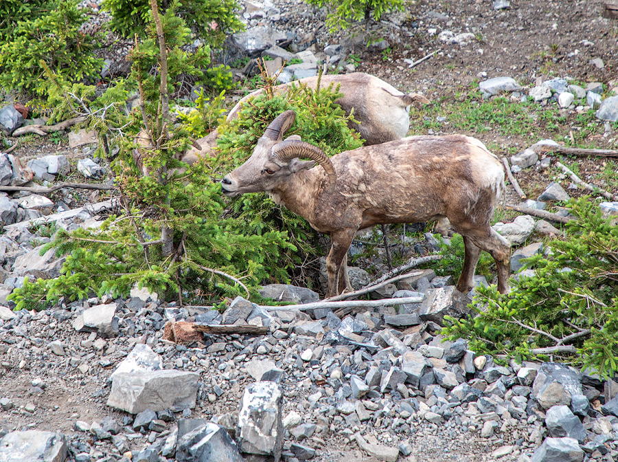
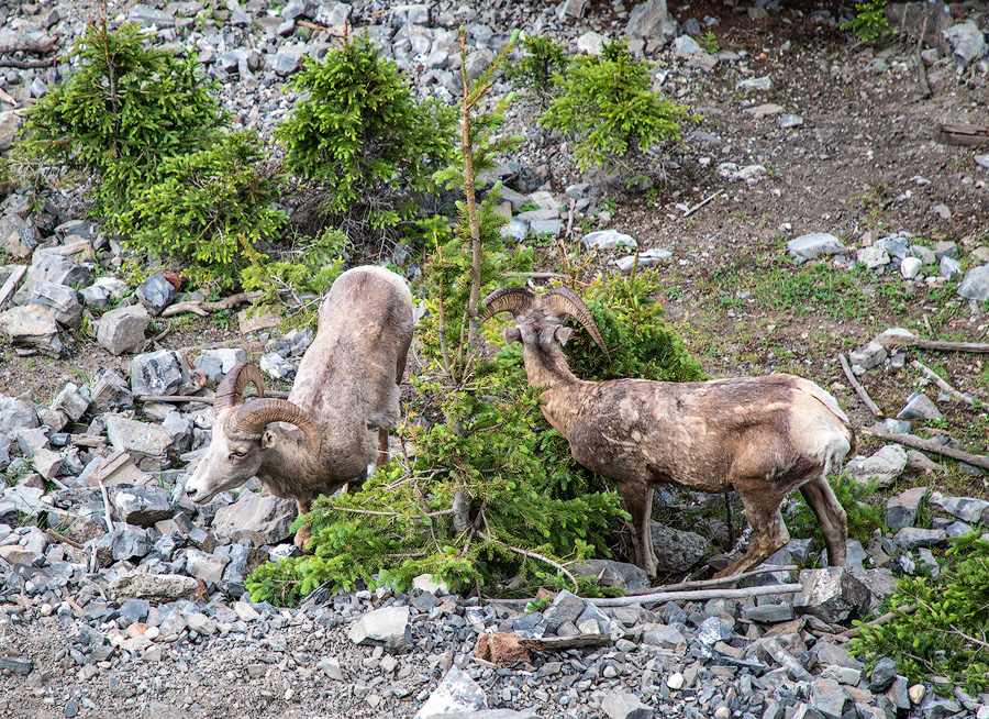
We stayed two days in Banff. The gondola ride over to Sulphur mountain is a nice family activity. Short board walk between Sulphur and Sanson peak offer great views all round and gives bird’s eye view of the Banff town. If you are lucky, you may have glimpse of small herd of Big Horn sheep that lives on Sulphur mountain.
Big Horn SheepBig Horn Sheep
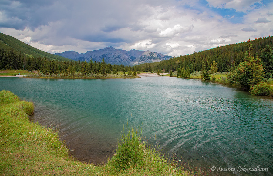
Cascade Ponds just outside Banff town is an excellent place for sunrise and sunset pictures. Mountains around the ponds makes it possible to compose great pictures in many directions based on clouds and lighting conditions. There are nice picnic grounds around ponds for a family picnic.
Cascade Ponds
Continuing on the same road takes you to Two Jack Lake and Lake Minnewanka. Two Jack Lake picnic area offers great views of Mt. Rundle towards the south and Mt. Inglismaldie towards the east. Lake Minnewanka is the largest lake in this area. Pursuit operates boat rides in lake Minnewanka. It was a nice, but overpriced. I’d rather take a boat ride at Lake Maligne in Jasper, and trade the boat ride in Minnewanka for kayaking in Two Jack Lake if weather permits.
When I laid down on boulders at Lake Minnewanka, this Golden Mantle ground squirrel came very close to me. I thought it was trying to beg for food, but it was very aggressive. No burrows were around so it’s unlikely it was protecting its nest and potentially off-springs. But it was funny that it thought with its growling and chattering, it could intimidate me. Whatever its fuss is about, it gave me nice close-up shots. Unfortunately, I couldn’t pay remuneration to my model. Feeding squirrels is very dangerous, as it creates behavioral problems and makes them aggressive towards humans. Please restrain from feeding wildlife.
The approximately 2 miles hike from Banff Town (Banff Ave) to Bow falls is very nice. The falls itself is not very tall, but the rushing waters of Bow river with small elevation loss creates dramatic turbulence.
Bow Falls
Vermillion Lakes outside Banff are a great place to shoot/enjoy sunrise and sunset. Mt Rundle and Sanson peak of Sulphur mountains are visible across the lakes. There are three lakes adjacent to each other. From Banff town, on Mt Norquay road going towards Tran Canada Highway 1, take Vermillion lake drive on left just before highway ramp.
Vermillion Lake
Johnston Canyon is another fantastic place in Banff area. Take Bow Valley Parkway (HyWy 1A) to Johnston Canyon. This route is alternative and much more scenic drive between Banff and Lake Louise. Johnston Canyon Trail is mostly a steel catwalk attached to canyon walls. Walking along the deep canyon walls with the rushing blue waters of Johnston Creek below, with the occasional small waterfalls is a fantastic experience. Johnston Creek is tributary of the Bow River that drops significantly twice along the trail. Lower falls is about 0.7 miles and upper falls is 1.6 miles one way from the trail head. Busy days, parking is kind of limited, so I suggest visiting this place in the morning. There is a nice restaurant at trailhead for lunch.
Our next stop was Lake Louise. We stayed in Lake Louise Inn in the village. Lake Louise is a relatively small lake, but one of the most beautiful lakes in the area surrounded by Fairview mountain (looking from the shore near Fairmont hotel) and Mt. Lefroy, Mt. Huber, and Mt. Victoria in the back, and Mt. Whyte and Beehive in the right. Lake Louise might have been a lagoon near Victoria Glacier tongue once, but the glacier receded back quite a bit. You can rent a kayak at Lake Louise Boat house. There is hiking trail around the lake. Another trail takes you to Lake Agnes Tea house. It’s about 2.2 miles one way with ~1300ft elevation gain. It’s worth hiking up to have a sip of tea next to Lake Agnes.
Lake LouiseLake Agnes and Tea House
Moraine Lake is another gem in Lake Louise area. Moraine Lake is one of the lakes with a deep color. The blue color of these lakes comes from the light reflected of silt that is suspended in the water. As glaciers move, they grind stones beneath them. The Canadian Rockies have a lot of quartz, which is grinded by glaciers into fine silt. Silt is carried by glacial waters into lakes. Grinded powder is so fine, it will not sink to bottom. It will suspend in the water and reflect off the light. Moraine Lake surrounded by beautiful mountains. From the far end (right of the image) to these near peaks are Neptauk Mountain, Deltaform Mountain, Mt. Tuzo, Mt. Allen, Mt. Perren, Tonsa Peak, Mt. Bowlen, and Mt. Babel.
Moraine Lake
Parking at Lake Louise and Moraine Lakes is really troublesome. During the summer months, starting from 7AM to around 6PM, parking is restricted at both Lake Louise and Moraine Lake. Parks Canada run shuttles from overflow parking on Trans Canada Highway 1, about 5 miles from the Lake Louise Village. I went to Moraine lake around 4AM and walked over to rock pile. I was lucky to have low hanging clouds and a spectacular sunrise.
From Lake Louise, we took Ice Field Parkway (HyWy 93) towards Jasper. Herbert Lake is the first lake on Ice Field Parkway. The following image was made during sunset. When I started from hotel, it was hopelessly raining. But if the weather changes, these are the ideal conditions for great sunsets. Just a few minutes before sunset, the rain stopped and the clouds started to clear. It took a few more minutes for the lakes to calm down for great reflections of Mt Temple, Fairview Mountain and Mt. Saint Piran. Herbert Lake is a good spot to photograph sunsets and sunrises as well.
Herbert Lake
Our next stop was Bow Lake. We stayed at historic Simpson Num-Ti-Jah Hotel at Bow lake for one night. Bow lake is a beautiful lake at the foot of Crowfoot Mountain and Crowfoot glacier. We haven’t explored this area due to rain, but I’ve heard highly about the trail that leads to Bow Glacier falls.
Crowfoot Mountain and Bow LakeCrowfoot Mountain and Bow Lake
Peyto Lake is another strikingly beautiful lake. Small hike from parking lot off of Ice Field Parkway takes you to viewing deck, from where you can see Peyto Lake at foot of Caldron peak (north-east face). I went twice to photograph Peyto, but both times, I was invited with rain and wind.
Peyto Lake
Next stop was Water foul Lakes. Its excellent place for sunset. But I couldn’t stay for sunset ( sunrise). I realized, staying in hotels is not convenient way to photograph the Rockies. You need to rent a small camper/RV and stay close to your location such that you can reach right time to the right location.
Water Foul Lake
Mistaya Canyon is a hidden gem that many people miss out. It’s wonderful place to sit back and enjoy rushing waters that disappear into deep canyon. View of Mt. Sarbach is great with foreground of rushing waters of (what I think…some correct me, if incorrect) a tributary of Saskatchewan River. This is great place for shooting sunrise and sunset.
Mistaya CanyonMistaya Canyon
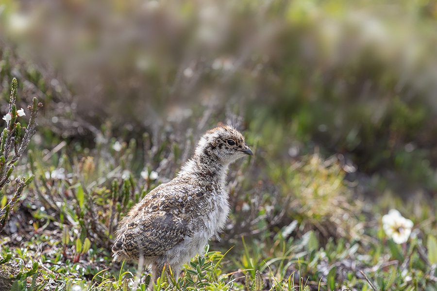
Parker ridge is one of the best hikes we did in this trip. It’s 2.8 miles round trip from trail head, which is located about one or two kilometers before Columbia Ice Field Center. Total elevation gain of the trail is just about 900ft. Once on the top of the ridge, views of Saskatchewan Glacier and head waters of Saskatchewan river are gorgeous. It’s exceptional panoramic view. Waiting for a sunset at this location will be definitely be rewarding. I couldn’t wait until sunset. But I made a promise to myself to return one day to shoot sunset here.
Parker Ridge View of Saskatchewan Glacier
On the trail, we saw Spruce Grouse. Poor mom stressed out with disobedient chicks roaming all over without fear of visitors.
Spruce GrouseSpruce GrouseSpruce Grouse Chick
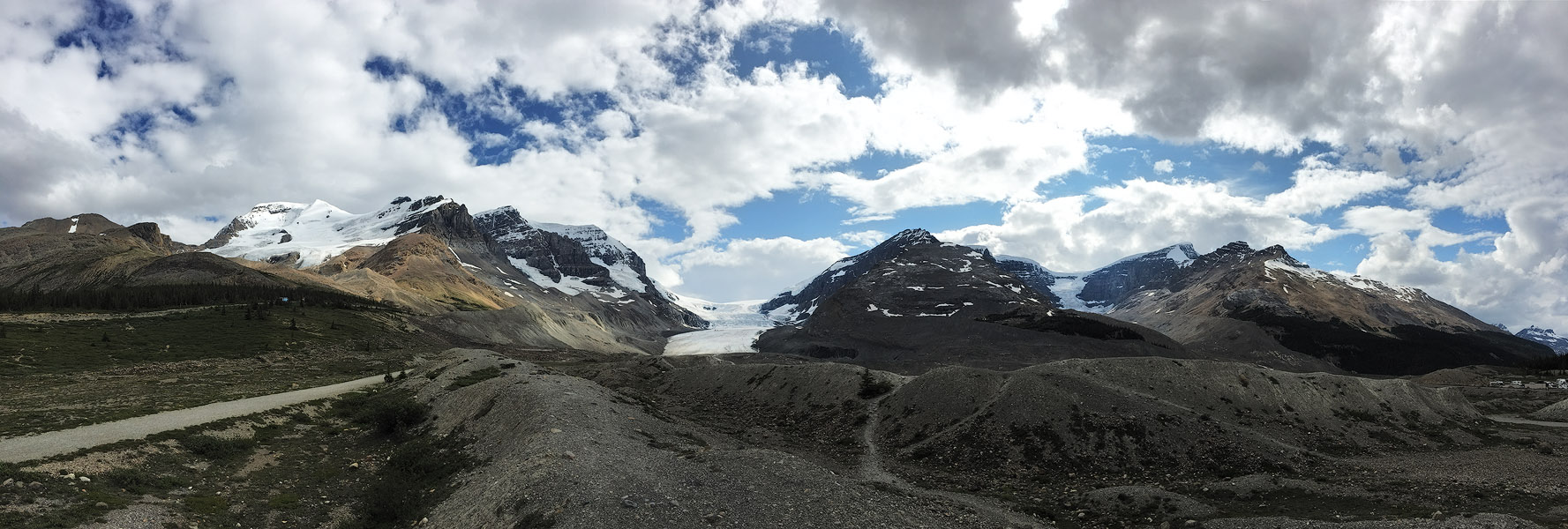
Columbia Ice Field Center comes about a miles from Parker ridge. Across the road, you can see spectacular Athabasca Glacier. Receeding year by year, but still magnificient. Surrounded by Boulder Mountain, Mt. Athabasca, Mt. Andromeda, Snowdome and Mt. Kitchener. Athabasca is actually a glacier tongue of Columbia Ice Field. The Ice Field is on triple continental divide. Waters from the glacier formed into three different rivers and eventually flows into three different oceans. Pursuit offers Glacier Bus Tour. These are special vehicals can drive on ice. Its unique experience to walk on glacier with hundreds of feet ice beneath you.
Athabasca GlacierAthabasca Glacier from Columbia Ice Field Center
You will find Tangle creek Falls as you drive few miles from Columbia Ice Field Center towards Jasper. It’s nice a cascades.
Tangle Creek Falls
Photography wise, I liked next two falls on Athabasca River (or it’s tributary Sunwapta River). Sunwapta upper falls is spectacular. Before the drop, Sunwapta river splits in two and re-converge as it plunges down 60 feet. Small Island that is created by the river before the drop is unique feature of this falls. With mountain backdrop and gorgeous water color, this is picture perfect place. It’s good for both sunrise and sunset. Falls can be viewed from the bridge across the river right opposite to falls. But river is not completely visible from this location.
Sunwapta Falls
Those background trees are not displaying autumn colors. That is dying pine forest. Pine Beetle infested Jasper National Park and 90% of the forest is dying right now.
Athabasca falls is small but spectacular falls. Before the drop, river cascades small steps, which is great foreground subject compliments with Mt. Kerkeslin in background. This location is great for sunset.
Athabasca Falls
We did not explore much of Jasper other than Maligne Lake. Pursuit runs boat rides on Maligne Lake, which take you to Spirit Island. It’s great place. Spirit island itself is not anything special in it’s appearance, its background settings is splendid with grand mountains both sides of the lake. Unfortunately tour boat does not stop more than 15 min. there…let alone taking sunset pictures. The only way to get to this place by ourselves is by kayaking. Kayaking one way takes at least 6 to 8 hours, according to a ranger that I spoke. Motorized boats are not allowed in the lake. However, she told me that one can get battery operated motors that can be attached to Kayak to make things easier. I would one day really want to Kayak up there and stay for couple of days.
Maligne LakeSpirit Island
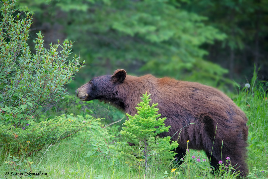
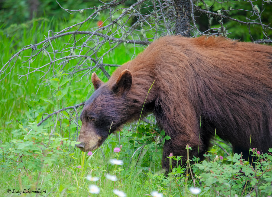
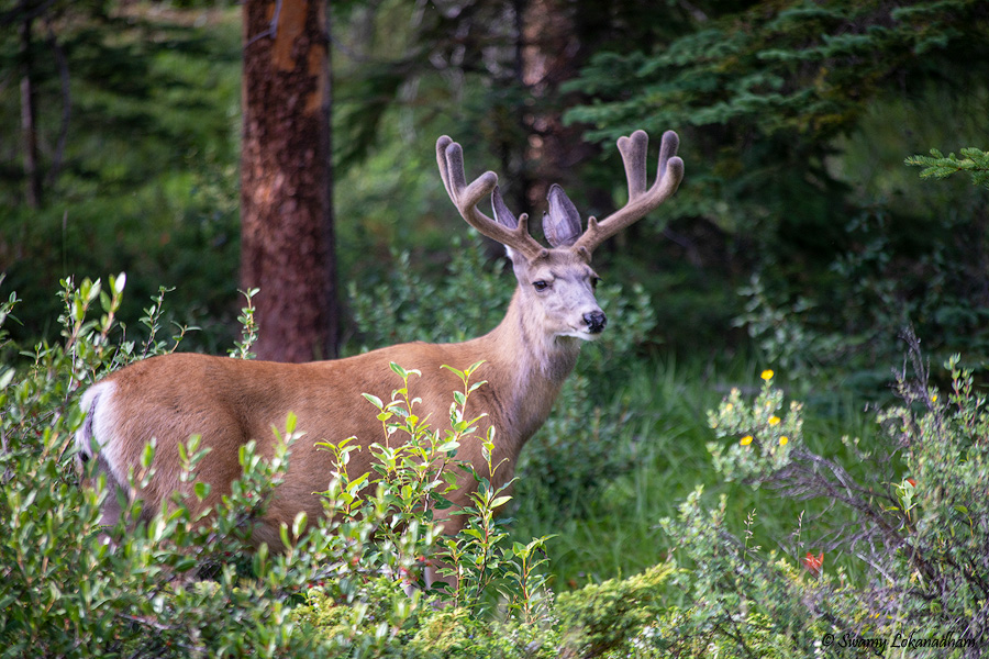
Entire trip, my eyes were wandering around to spot mountain goats, but no luck this time. But we were lucky to see many black bears up close. This is prime time for them to munch on buffalo berries.
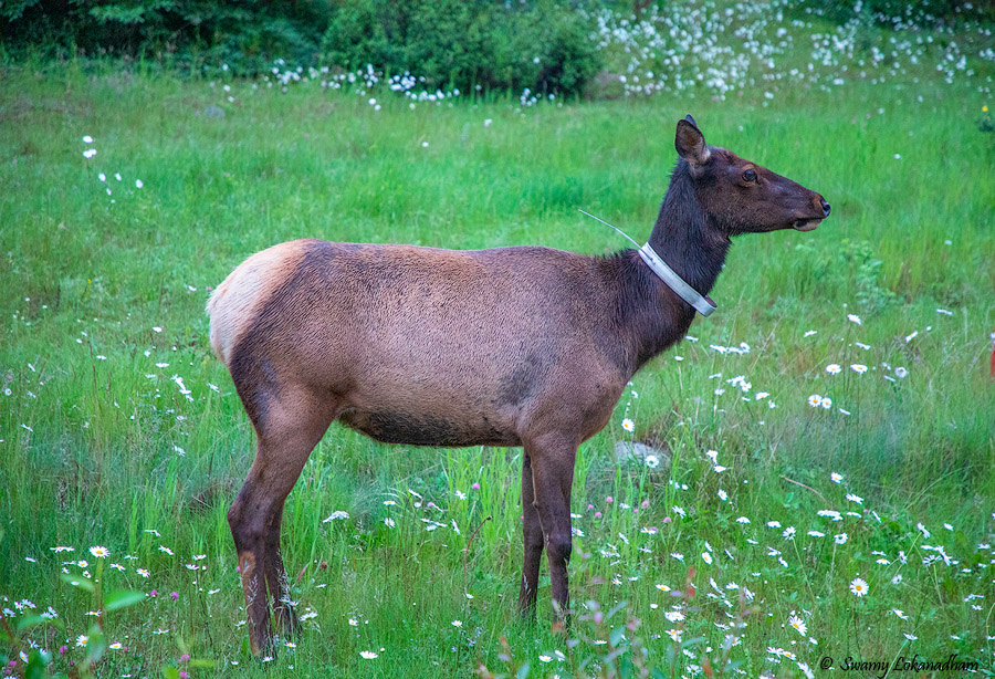
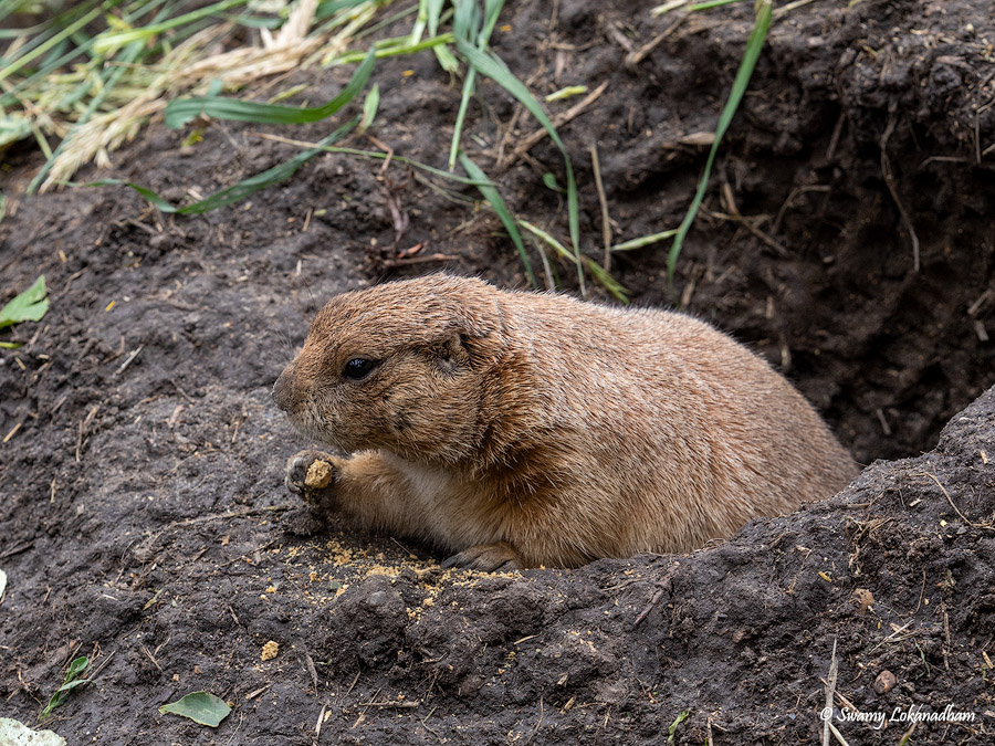
Buffalo Berries Black Bear Munching Buffalo BerriesBlack BearDeer Licking saltMale ElkElkPrairie dog
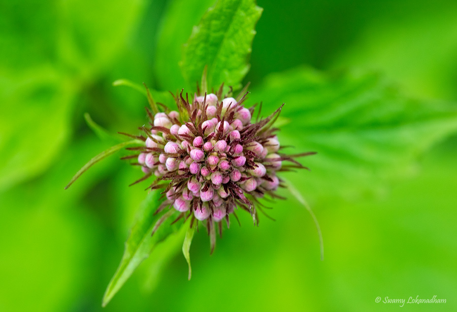
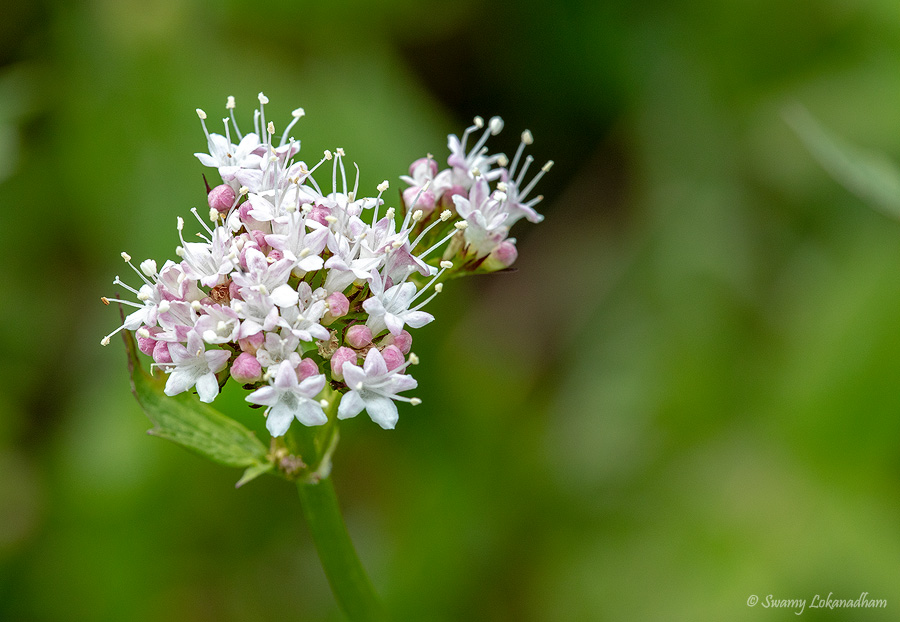
Alberta is known as wild rose country. Although, I have seen these wild roses in Sierras in California; Rockies have more abundant. Some other wild flowers bloom at this time of the year.
Wild Rose and BeePaint BrushAlfalfa FlowerWestern Chalice FlowerCanada AnemoneSitka ValerianThe Prairie Lily or Western (wood) Red LilyYellow Mountain AvensSwamp Buttercup Sitka ValerianWhite Mountain HeatherWestern Indian Paint BrushMoss Campion Silene Acaulis
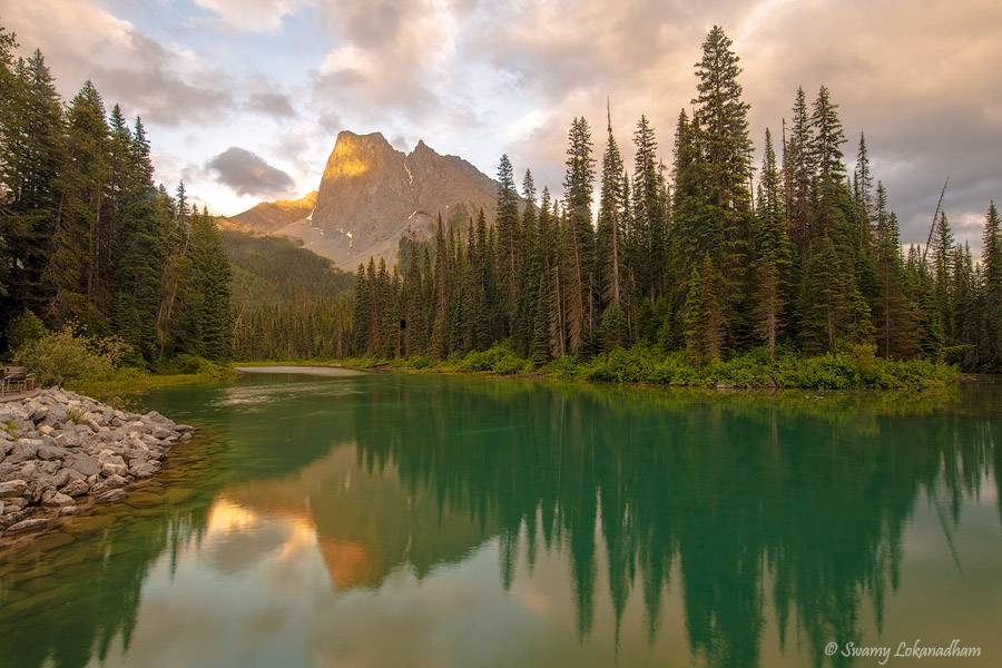
We have visited only two places in Yoho national park. Takkakaw Falls and Emerald Lake. Both are reasonably close to Lake Louise area. I'm particularly very impressed with Emerald Lake. The lake is surrounded by beautiful mountains. Based on the could cover, sunset/sunrise pictures can be taken literally from any direction.
There where the mighty mountains bare their fangs unto the moon;
There where the sullen sun-dogs glare in the snow-bright, bitter noon,
And the glacier-gutted streams sweep down at the clarion call of June:
There where the livid tundras keep their tryst with the tranquil snows;
There where the Silences are spawned, and the light of hell-fire flows
Into the bowl of the midnight sky, violet, amber, and rose:
There where the rapids churn and roar, and the ice-floes bellowing run;
Where the tortured, twisted rivers of blood rush to the setting sun –
I’ve packed my kit and I’m going, boys, ere another day is done.
* * * * *
I knew it would call, or soon or late, as it calls the whirring wings;
It’s the olden lure, it’s the golden lure, it’s the lure of the timeless things;
And to-night, O God of the trails untrod, how it whines in my heart-strings!
I’m sick to death of your well-groomed gods, your make-believe and your show;
I long for a whiff of bacon and beans, a snug shake-down in the snow,
A trail to break, and a life at stake, and another bout with the foe;
~Robert William Service
Well, I don’t have craving for whiff of bacon and beans like Service in wilderness, but my cravings for mountain air filled with fragrance of sage and pines lures me to wilderness. Last weekend, I backpacked into Hoover wilderness along with Rama Krishana, Mallik Vantedu, Sai Padimiti and Satya Boora for two days.
We started on Friday night from San Ramon and reached June lake around 2AM. Our plan was to hike into 20 Lakes Basin from Saddlebag Lake. Saddlebag trail also needs wilderness permit for backpacking, however there are no permit quotas. There are very few trails in Inyo National forest that does not limit number of permits per day. we picked up our permits from Mono Basin Scenic Area Visitor Center in Lee Vining and set out to the trail head. Saddlebag Lake is just few miles away from Yosemite National Park east entrance. Road to Saddlebag lake turns left after about 2.2 miles from east entrance of the park towards Lee vining. Another 2.5 miles on semi-dirt road takes you to Saddlebag lake. Saddlebag lake is the highest elevation lake (at 10,090 ft.) in California that one can driver to.
Our plan was to go around the Saddlebag lake and enter 20 Lake Basin and camp out far end of the basin. The Basin is surrounded by beautiful peaks including Tioga Crest(Elevation:11911 ft.), Excelsior Mountain (Elevation:12,446 ft.), Shepherd crest(Elevation:12,040 ft.), North peak (Elevation:12,247 ft.) and Mt. Conness (Elevation:12589 ft.). Trail itself is a very easy 9 miles round trip with about 500 ft. elevation gain.
Our trail route (9 miles total) (Green line is part of 20 Lake Basin trail as well)
We started our hike at 12:30PM from east side of the lake. We supposed to take Lundy Pass towards Helen Lake, instead we took trail that leads to Stealhead lake. Weather was excellent. Afternoon rain in forecast, we had nice cloud cover through out the afternoon. Breeze was intoxicatingly fragrant, perhaps from some kind of sage brush. Most probably, Mountain sliver sage. I can recognize California sagebrush (Artemisia California), which is very distinct from other sage varieties, but it’s impossible for me to differentiate one sage subspecies to others. Typical Sierra rain comes and goes pretty quickly. We had few showers as we approached Greenstone lake.
We took lunch break at Greenstone Lake
Mallik praying for world peace ( 🙂 ) at Greenstone Lake …Storm brewing over North peak and Mt. Conness in back drop.
This is the biggest group and humor-filled backpacking trip that I ever did 🙂
After Greenstone lake, trail is bare with almost no tree cover, but offers exceptional views to Shepherd crest, Excelsior Mountain and North Peak as we cross Wasco lake. Trail ascends as it contour around north end of Steal head lake and enters rocky basin between Cascade lakes and Stealhead Lake. We found a small meadow near small lake at foothills of North peak and camped for the night.
Sunset was good; there were clouds and color, but not where we would like them to be. So did not bother photographing sunset. South skies were clear, so hoping for good view of milky way in the night. But as we geared up for night photography, a huge cloud came and covered south skies.
Night was peaceful, QUIET and cold.
We woke up early for sunrise. There is some mystic nature in alpine glow on mountains during sunrise. I’m neither a mystic nor science can not explain the phenomena, but that moment has magical impression on observers. Never fails to bring gaiety in the nature’s admirers.
Alpine glow on North Peak
Some of the images from that same location.
After regular morning chores, we packed up and started our hike back. From Greenstone lake, we took trail that goes from west shore of Saddlebag lake. We traversed couple of snow patches on that trail.
Yes, there is still lot of snow at elevation starting from 10,500ft to 11,000 ft. as late as end of August. It’s not typical, but we had above normal snow accumulation this winter. As we cross reservoir, saw that Saddlebag is spilling over the spillway into Lee Vining creek, first time for about 34 years (1983), which underlines the good snow year.
We reached trailhead around 12:30PM. 20 Lake Basin is great place for first time backpackers… easy trail and great views…easy to get permits !
I’m in hate and love relationship with summer. Temperatures climbing over 100 degrees Fahrenheit binds me indoors at home. But same raising temperatures melts snow on higher elevations and opens up high country for backpacking. We had above average of snow accumulation in California last year. Many trails are still buried under snow and creeks and rivers are roaring with flood of water from snow melt. Conditions are getting better at high elevation day by day.
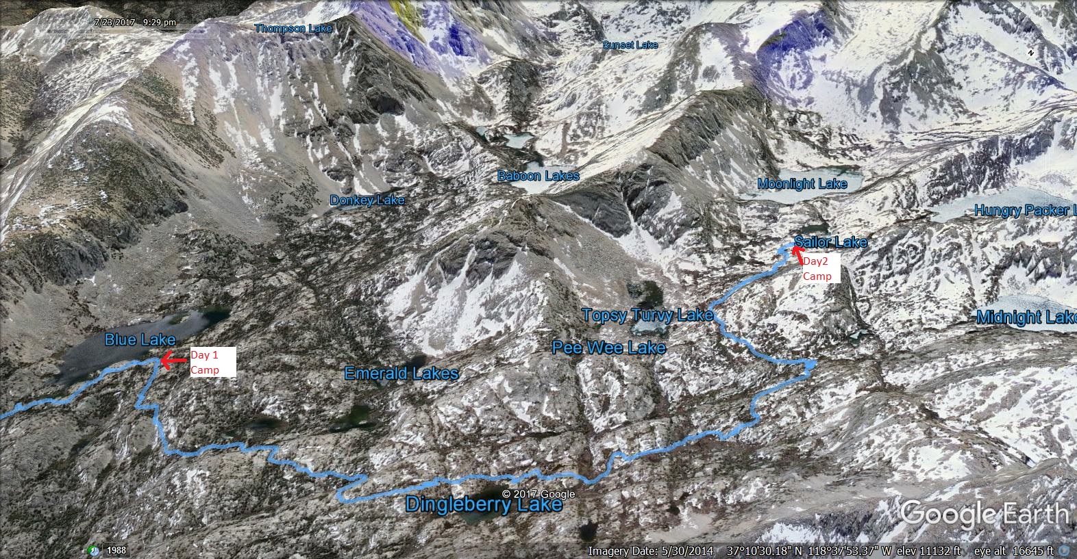
Last week I went on my first backpacking trip of the year (7/21/2017 thru 7/23/2017). I originally planned to hike up to Ediza Lake in Mammoth lakes area. Unfortunately due to road closures (road bed compromised due to soil erosion caused by snow melt), I had to drop that plan. Saket Jain and Ashish Shah joined me on this trip. We started from home at 10PM on Thursday after work and reached Bishop around 3AM. Slept few hours and reached ranger station in the morning to check out trail conditions and obtain permits. I was expecting usual long lines for back country permits. To my pleasant surprise, no line at all. I was suspicious about trail conditions in high country. We enquired about Sabrina lake basin conditions. Ranger told us that we may hit snow at 10500 ft. and above. He also urged to be very careful at creek/river crossings. Plenty of permits available (made me more worried than happy). We did not get very clear picture on trail condition, but decided to carry micro spikes (to get traction on snow) and pursue the trail with open mind. Decided to turn back, had we come across a river crossing or snow field that is impassable. Since we are starting on Friday, instead of two days, we have three days to finish the trail. My plan was to hike up to Hungry Packer Lake, which is located at 11000 ft., at foot hills of Picture Peak (unofficial peak name; according to USGS, its part of Mt. Haeckel).
We drove up to Sabrina Lake. We did not find any dedicated overnight parking. We parked roadside about a quarter mile from trail head. We started the hiking at 12PM.
Trail head is at 9070ft elevation. Trail was well shaded for some of the sections with of course lot of sections exposed to sun. Trail immediately started climbing up from Sabrina Lake. We hiked with very relaxed pace knowing that we have two days to hike up to hungry packers lake. After George lake trail junction, we came across our first creek crossing (out of 6) at a waterfall. Lake Sabrina has two major inlets. Drainage from George lake in the south and a confluence of drainages from Blue, Dingle Berry and Fish Gut lakes in the west. The one we came across was the drainage from George lake. We decided not to do boulder hoping with packs, but simply walk through it; did not want to risk 1000ft slide down to Sabrina lake.
We stopped for lunch around 3PM. Saket has been lugging puri with achar that his sister packed for him. It’s the best lunch I ever had on trail. Thanks for Saket and his sister. I still remember the store bought tortillas and mango pickle that I forced myself to eat on John Muir Trail couple of year back.
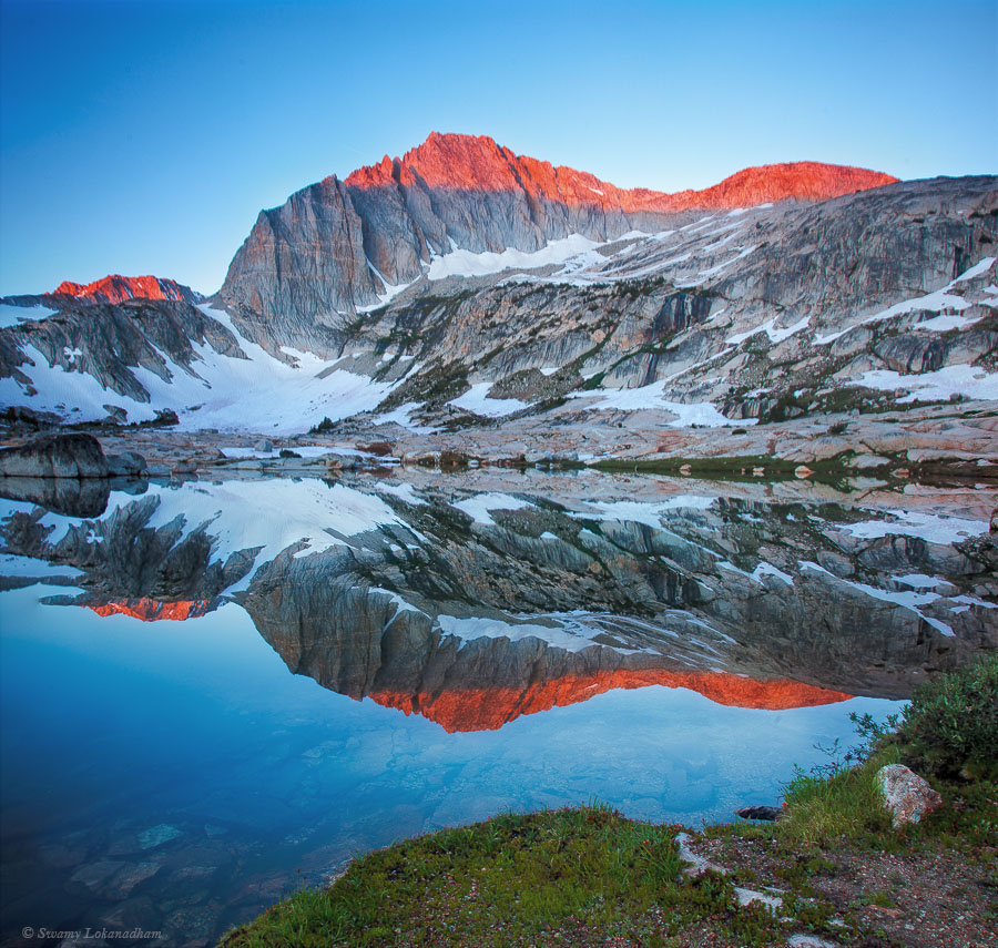
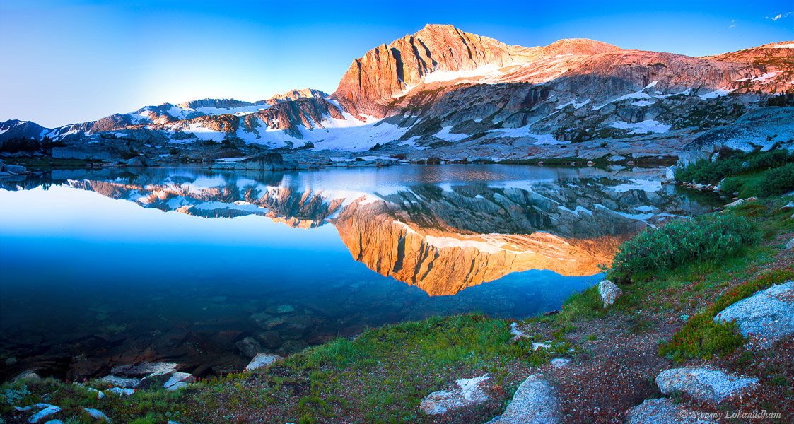
We reached Blue lake (at 10500ft.) around 5PM. We wanted to push forward to Dingle Berry Lake for the night. But Saket started to feel light headedness and head ache, typical high elevation symptoms. We had hardly any sleep last two nights and did not properly acclimatized. Going from sea level to over 10K ft. elevation without acclimatization definitely has repercussion. Our decision was clear. We stopped at Blue Lake for the night. We had plenty of time anyway to reach Hungry Packer Lake tomorrow. It was good decision. Blue lake was great place with beautiful views. It’s nestled below Mt. Thomson and Mt. Powel.
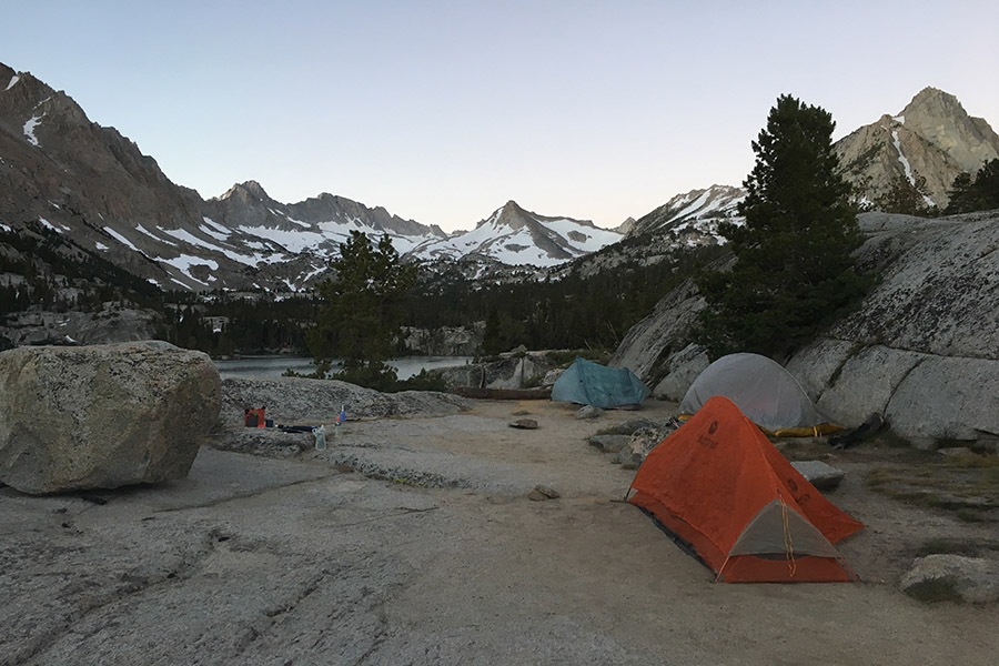
Here is our first day camp site.
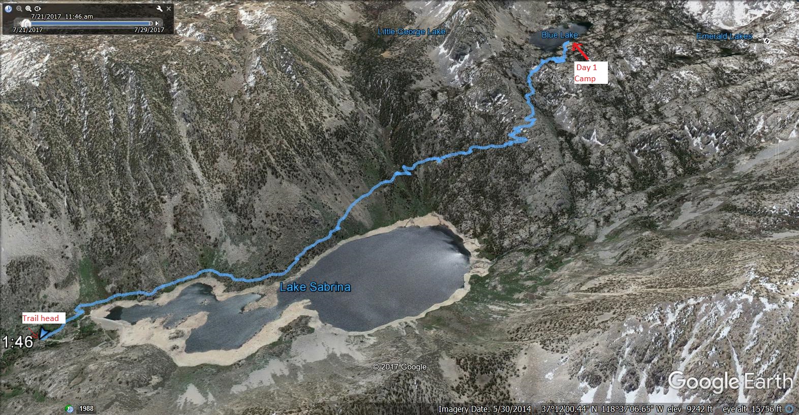
Day 1 route.
We did not shoot sunset, but took some milky way pictures.
(Search for extraterrestrials …with flashlight 🙂 … thanks to Ashish for modeling )
Ashish doing Pranayama in the morning. Pranayama is yogic breathing exercise.
After we finished morning chores, we started on our way to Hungry Packer lake.
We started to see patches of snow starting from 10500ft., but we could easily bypass them. Micro spikes and gaiters that I was carrying were sheer waste of extra weight. Trees started to be thinning out, but continued to be dominated by what appears as White bark pine and Lodge pole pines.
Watermelon Snow …
We saw lot of watermelon snow. Red color in snow is caused by a kind of snow loving green algae that grows on snow as temperatures warm up. In addition to chlorophyll, they have red carotenoid pigment also.
Mosquitos were horrendous. We proved that there is nothing better than deet to fight mosquitos 🙂
At Dingle Berry Lake
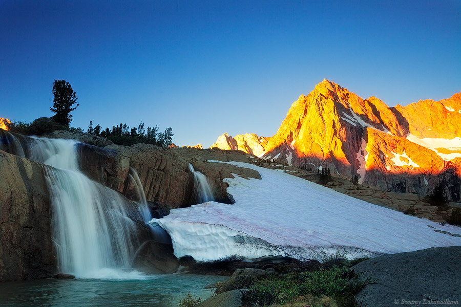
We reached Moon light falls (11,000 ft.) by 3 o’clock. We immediately loved the basin and decided to camp there. My plan was to shot Moonlight Falls at sunrise with picture peak in background. So decided that’s right place to camp out.
Here is our camp site of day 2, at foot hills of Mt. Powel and Picture Peak (It’s not official name. As per USGS, its part of Mt. Haeckel).
We camped close to Sailor lakes. Here is our day-2 route.
Here are some pictures from that area
Next day, we started at 9:30 AM and returned to trail head by 4PM.
Enjoying my morning coffee and Kachori (an Indian spicy snack). We hiked about total 14.5 miles and elevations (effective) is about 2500ft. in three days. It allowed us to take many breaks and enjoy each location thoroughly.
Good rain year brought spectacular flowering season this year. California spring was colorful this year. But I could not make a single trip during spring to anywhere. As spring wrapping up and temperatures started to rise, I know lupines bloom reaches peak on Bald Hills of Redwood National Park at this time of the year. I made a weekend trip to Redwoods. It’s over 12 hours drive (to and fro) to spend 12 hours in the park (well, better than not going at all).
Lupines bloom is spectacular as expected. I picked up my location and waited for sunset. I composed image such that a sun-star to form in the middle when the sun get below the oak trees on horizon. As it about to happen in another couple of minutes, fog rolled in like magic. Adopting to situation, I had to change my composition.
Next day I went in to the Coastal Redwood forest. Coastal redwoods are tallest living species that grow up to 370ft. Fog that comes from ocean keeps this forest humid. As sun rises over horizon, fog dissipates and let sun rays penetrates. Fog, Sunray beams create a great magical ambience. I waited 6 hours for that magic to happen, but fog was so dense that day, sun had no chance and deprived my chance to that shot. But I had good 6 hours at this location. So. finished William Golding’s Lord of Flies. An excellent read; particularly to kids. It’s an open ended conclusion (not story wise, but it’s moral teaching). So gives an excellent opportunity for an evening discussion with kids on philosophy.
Without further deviation, here are images from Lady Bird Johnson Grove.
Yesterday, I and Naresh made a day trip to Yosemite (5/20/2017). Valley is teeming with dogwood bloom, thundering waterfalls, joyous Merced flow and unfortunetely with lots of crowds. No, I’m not antisocial. As soon as we entered Yosemite valley floor, we were stuck in traffic on southside drive. It took 2 1/2 hours from Pohono bridge to Curry village (yes, I’ll continue to call it curry village. I’m not calling it halfdome village), which generally take 10 min. So, we are obviously miserable. We roamed around at bank of Merced near housekeeping camp (below picture). But did not feel like staying in the valley for long.
It took another hour to cross Yosemite falls from Curry village (which takes 5 min. generally). But as we crossed yosemite falls traffic was better on Northside drive. So we stopped at Valley view and settled to enjoy the sunset.
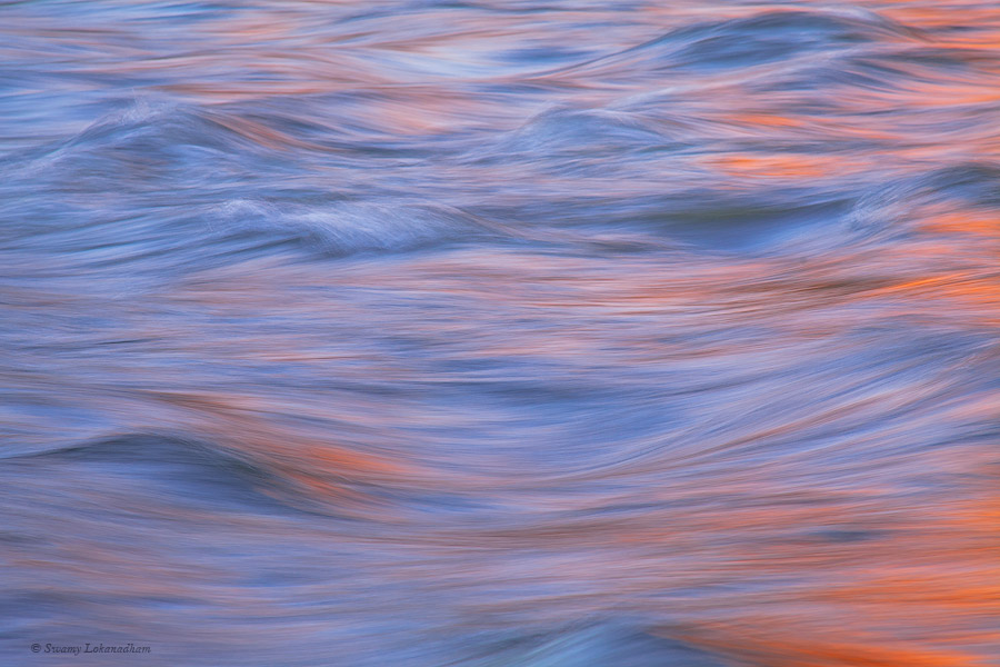
Initially, I did not bother to shoot, but as I saw water shimmering in reflected light, I couldn’t resist. It was amazing play of light and rushing water.
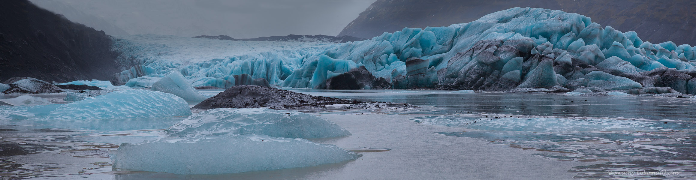
When you hear the name Iceland, a thought of being there in winter sends shivers down the spine. Snow dominant sceneries comes to our mind. That being true to some extent, Iceland is more than just ice. In fact, the expression “Ice and Fire” is well suites to Iceland than any other place. Greens of highlands, blues of glaciers, dark shades of black sand beaches and beautiful orange shades of sunrises/sunsets over warmer coast lines together define Iceland as crown jewel of natural beauty. Warmth and simplicity of Icelanders is the sparkle of that jewel.
My primary motivation of this visit is to photograph northern lights (Aurora Borealis) and ice caves. Aurora Borealis is green light (there can be other colors a well) that dances in the night skies of polar regions. Electrically charged particles from solar winds interact with oxygen and nitrogen atoms of Earth’s upper atmosphere cause these lights. I have seen photographs and movies, but never witnessed in person. Ice caves are formed in the glaciers, when water flows under glacial ice through cracks or crevasses and eventually widen the gap by eroding/melting ice. Those caves are amazing inside. Unfortunately, I could not see northern lights due to bad weather conditions. Also due to weeks of rain days, all ice caves are either flooded or roofs are collapsed. Ice caves form and collapse every year. You need to wear good micro-spikes (as below image) or crampons to walk on glaciers. If you have to walk on steep areas, carrying an ice axe is advised.
This cave is formed at foot of the glacier with eroded soil. So the ice is mixed with mud and look black.
The cave under construction (or may be towards destruction !)
In contrast to my typical solo trips, I joined a photograph tour group in this trip. The eleven complete strangers that I met before the trip are now I can call friends for life. That itself is a great experience in this trip. Formula for such phenomena is that everyone in the group like same beer 😉 . Alban and Kasper (Tour leads) planned our locations dynamically based on weather conditions and Eidur drove us in Big Red to get locations on time.
We stayed in south and south-east coastal areas only.
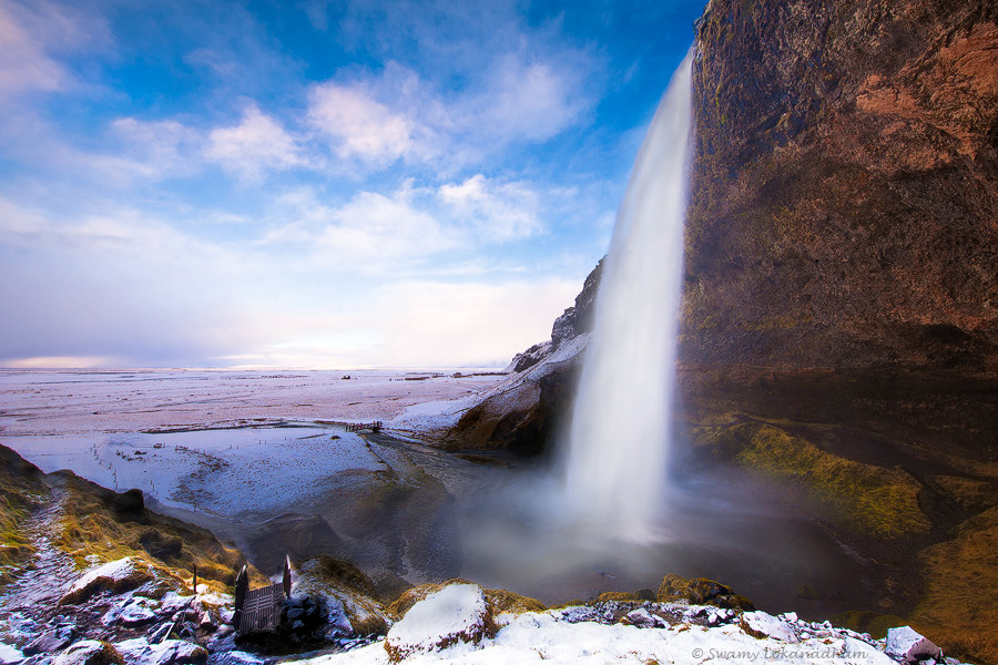
Seljalandsfoss (Foss means water in Icelandic)
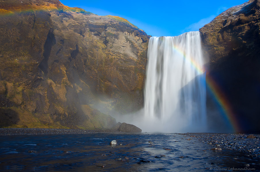
Skógafoss
Both these waterfalls are close to Eyjafjallajökull volcano (5466 ft.) that erupted in 2010. Vík is the closet town to this area. Here is sunset image from black sand beach near Vík.
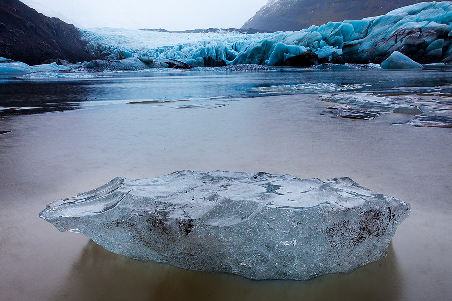
Svínafellsjökull.
Jökull means glacier in Icelandic. But this is just one of many tongues of Vatnajökull glacier.
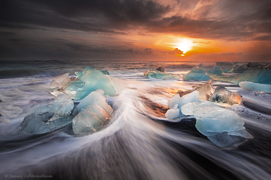
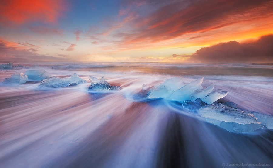
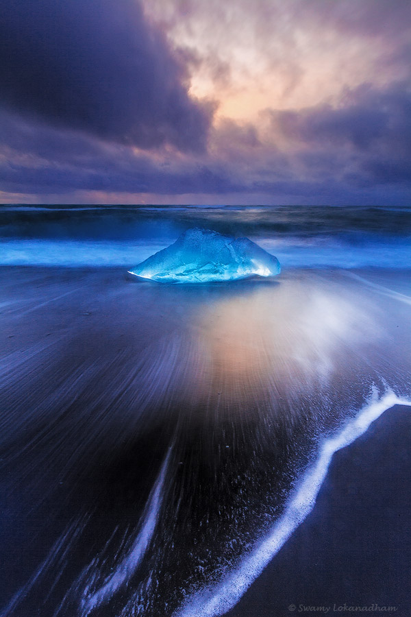
We stayed near Jökulsárlón, a glacier lagoon for two days and spent three sunrises photographing ice bergs in beach. Melting glacial waters form lagoons at the foot of glacier tongues (Haa, tongues with feet !). Jökulsárlón is one of such lagoons. Glacial ice that is separated from the mass, floats way into ocean. Proximity of the lagoon to the ocean makes it possible that ice bergs are pushed into ocean when wind blow in the right direction. Waves bring those ice bergs back on the beach and deposit them. It was wonderful experience to photograph at this location. Infinitely beautiful and unique elements to work with. Photographers need to exercise high caution and alert all the time at this beach. Some of the ice bergs are half size of SUV. If you are not alert, just one big wave is enough to knock you down. As you go close to ocean, ensure that your path to retreat is free of ice bergs. I had several close calls (not me, but for my camera) to shoot below images. at Diamond beach. Images from Jökulsárlón and Diamonds beach
Even though, we spent three days, I’m still longing to go back to this area.
Vestrahorn Mountains at Stokksnes.
Glacial Rose…Sólheimajökull
Gullfoss
Interiors of Iceland will be more accessible in summer. I want to explore highlands of Iceland someday and return in winters to photograph northern lights and ice caves. I noticed that coastal Iceland is almost like arctic tundra. Only two kinds of tree that I noticed, which are also very sparse. Birch trees, which are not more than 7 to 8 feet. May be groups of 10 or 15 tress together. They look more shrub than tree at times. Also one kind of conifer. I did not get chance to investigate closely, but locals said, it’s Juniper. Again, these trees are also not very tall, may be 9 to 10 feet only. I hope, I’ll get chance to explore more of highlands and get to learn more of Iceland.
I planned this trip to complete section of John Muir Trail (JMT) between Le Conte Canyon and Charlotte Lake junction in 6 to 7 days. To access JMT, I have to hike 13 miles from South Lake of Bishop over Bishop pass (11970 ft.) and climb Mather, Pinchot and Glen passes and exit from Kearsarge Pass. Inyo national forest issues permit for back country hikes. I got permit for Sunday (9/4/2016). There is quota for each day to enter the wilderness. Once you start the hike, you can stay in the wild as many days as you want. Permit quota is only for entry.
Here are notes from my journal.
Sept 4th 2016 (Sunday):
I realized last evening that I forgot to bring quick release plate for my tripod. I had to drive 12 hours straight to home and back for it. Penalty for not being diligent in packing. I reached back to Independence at 5:30AM. Took shower, finished other errands and reached South Lake trailhead at 10AM. I have been on Bishop pass for 4 times now. South lake is a familiar place, but this is the first time I ever the lake without bathtub rings. Bathtub rings are ridge lines form/visible around lake bank during drought years.
My progress on trail was slow. I started to feel the pack weight with in few miles. This is the heaviest pack (55+ lbs.) I ever carried. Since this is late in the season with dropping temperatures, I had to pack some extra layers. I also changed food this time. I packed mostly “ready to eat” Indian foods instead of dehydrated food. I took about 8 hrs to climb Bishop pass. I was tired to last bone. Sitting at camp now, I still don’t know, which factor mostly caused the disappointing progress; pack weight, acclimatization (or lack of sleep) or bad knees ?
I realized immediately that if I struggled for Bishop pass itself, Mather and Glen passes on JMT does not forgive me. Those two are known among JMT hikers to be notorious. I climbed down about 800 ft. to Upper Dusy basin to camp for the day. It may be good to stay couple of days at Dusy basin and return. No JMT this year.
Sept 5th 2016 (Monday):
Nice day. I slept well last night. Lack of sleep previous night or physical strain of the day helped me sleep like a baby. Generally, first night at high elevation is difficult to sleep. I was still on cusp between continue on trail or return. Physical exhaustion is common even for a strong experienced hiker while climbing up these mountain passes. But exhaustion to an extend that makes it impossible for you to appreciate nature around, beats the objective of hiking. I could not allow myself of such moral infringement by continuing on hike for the sake of reaching the end. As I always remind myself, it’s about journey, not just the destination. So decided to spend a quiet day here and return tomorrow back to South lake.
I realized that I never spent a complete day at one location during my hikes before…What place is better than this for that experience. Placid lake at foothills of Palisades group that stood over 14000ft elevation. Palisades group has 4 peaks that are over 14000ft. Grey granite with white streaks. I always wonder about these streaks. They start on one mountain and continue as straight line on adjacent one at same angle. You can see them on Mt. Winchell in my pictures below. They are like mountain graffiti. The only graffiti, well, second best graffiti that I like. First graffiti artists (that I like) of course are my kids; as toddlers decorated walls with their master pieces. Later artist were punished by mom for scribbling…who understand art these days, isn’t it? Anyways, graffiti artist on these mountains, nature, does not do anything without purpose and reason.
I sat before lake with coffee and Kachori (Indian spicy snack, not backpacking weight, but what the heck). A swarm of very small white bugs busy flying in and out from water. I don’t know what those are. They did not bother me, so I did not move from that place. Then I observed there are lot of brown trout also near the bank. They are coming from bottom and catching bugs as they jump occasionally out of water. Some just poke their heads and go down quickly. It’s fun to watch these fish. As lakes start to freeze, their survival is really a struggle and miracle. They stay at deepest point and slow down the metabolism dramatically. Lack of oxygen sometimes kill many fish during prolonged winters. Temperatures are already going low at this elevations. Last night, 1/2cm ice formed on top of water bucket. I could able to took it out of bucket without breaking ( See the picture below).
Sept 6th 2016 (Tuesday):
I hiked back to south lake. I climbed back to bishop pass with normal speed and ease. My knees are still strained, but did not bother. My pack weight reduced with less food and acclimatization for two nights that may be what caused my misery other day. But good lesson. I saw a bear, unfortunately it was pretty far (see picture below)
At times, I feel like a passenger in fast moving train on timeline. Zapping through days, weeks, months and years quickly. It just appears as a dream of yesterday. You put away due to lack of time. Years goes by, dream remains as dream. When it comes to physical abilities, age does not forgive anyone. You may age graciously, but you still age. Passing time can drift you far away from your dreams. When old age called upon you, you need memories of moments that you followed your heart, than remorse on list of unaccomplished dreams. Don’t put away your dreams. It never too late to throw off the bowlines. Sail away from the safe harbor. Catch the trade winds in your sails. Explore. Dream. Discover (Paraphrased Mark Twain words).
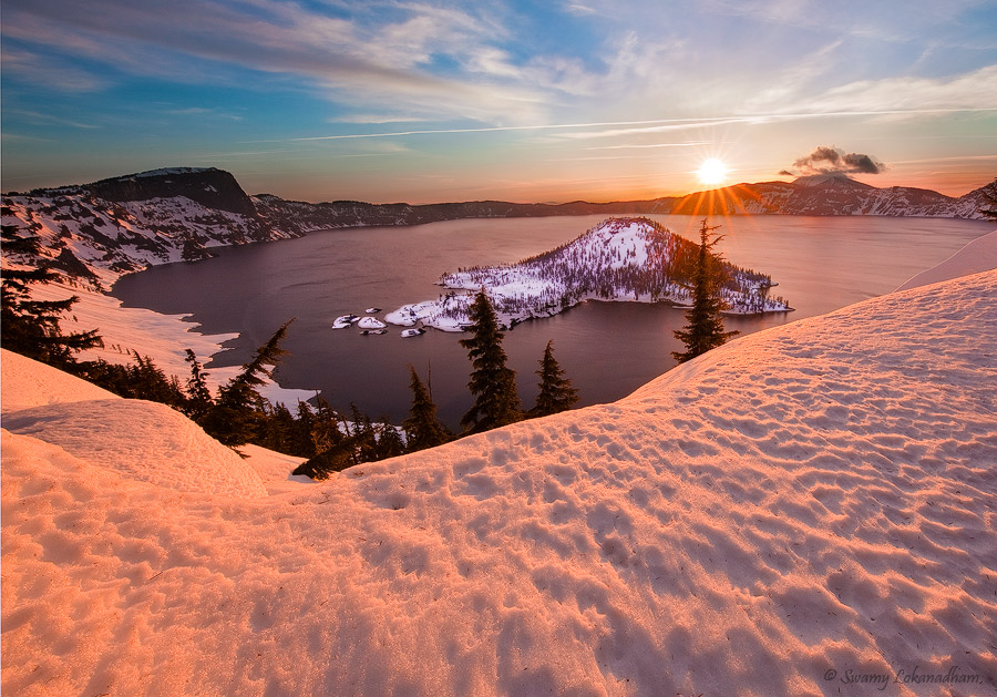
I have been longing to photograph Crater lake in winter for many years. It involves snow shoeing and backpacking in snow. Crater Lake gets on average 44 ft. of snow in a year. The lake formed when Volcano Mt. Mazama was blew off over 7700 years ago. I was under impression that road closes at Mazama Village at foothills for winter. Which means, one has to climb up 1100 ft. on snow to the rim and who knows how long to go around the rim for good views. So, I was putting this away to get proper training in back country survival skills in snow. I had to cancel the training last two seasons due to lack of time. Last week, I learned that road that leads to the rim is open in winter and people can snowshoe around the rim and camp anywhere on the way (at least a mile away from where you start). I did not want to push this to one more year. I have no experience in snow shoeing or snow camping. But you will never get that experience, unless you attempt. The secret of getting ahead is getting started (~Mark Twain).
I invited Saket to join last weekend for snow backpacking trip. He never refuses to a photography trip into nature. Together we did our first backpacking trip as well. So we decided to give it a try. I rented snowshoes and shovel on the way home from outdoor adventure company. Picked up some supplies from REI. Going in to wilderness in snow and camping is very tricky. I don’t have a four season tent. But snow is not in forecast for Saturday night. Even if it snows, I would not expect more than 2 or 3 inches. I went with my trusted Marmot EOS1P. Temperatures can go down below freezing, so I got JetBoil 4 season fuel. If your gear and clothing got wet, you are done. Hypothermia is a chilling reality one must dread while on snow for extended times. So I used a construction grade trash bag as backpack liner to protect from things getting wet, especially my down sleeping bag. I also changed my sleeping bad to R4 grade to get better insulation. I know we have to sleep on 10 to 15 ft. of snow. Learned from past mistakes, I wore proper snow boots and gaiters to avoid snow creeping into shoes.
With all the gear, our backpacks weighed over 50lbs. I know we have packed extra, but I didn’t dare cutting any corners. We decided not to go beyond 3 miles one way in this trip. To my surprise, walking on snowshoes was not difficult. Going down the slope was tricky, but it is fairly easy on packed snow. We hiked up 3 miles until we have wizard island in clear view and decided to camp out. We flattened area with shovel and build walls around to protect from wind. Later realized, how much this helped in the night. Wind was howling all night. Here are some picture of campsite building.
Sunset was amazing. Miles of snow surrounded around us below and hues of red in the sky…simply mesmerizing. We had to be very careful about cornices. Lot of them started to give away due to warming weather. Images at sunset and sunrise (next morning). I’m not particularly happy with sunrise image. I woke up late and did not get chance to explore and also did not catch sun at right spot (right spot is at edge of the mountains for maximum sun-star effect).
Wind was pretty bad in the night. But we came out safe without any incident. Hopefully, next year I’ll attempt hiking around the rim
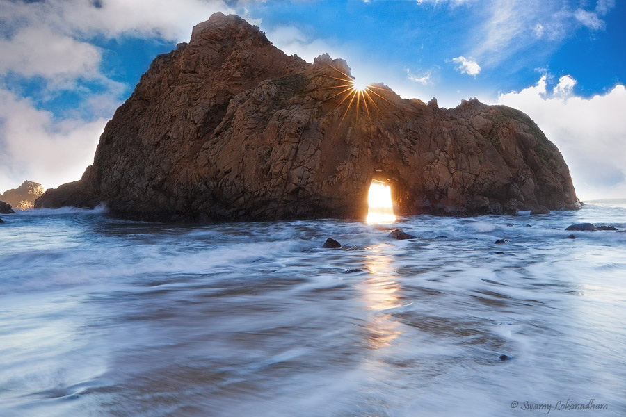
Keyhole arch is located at Pfeiffer beach in Big Sur, California. Sea arches are great photographic subject and fun to watch as waves swash through opening and drift to shore and recede. Every action in nature has purpose. Eloquent in action and relentless in pursuit. Nature is like a craftsman with great appetite to create masterpiece after masterpiece. Sea arches are formed as result of continuous wave refraction that erode weaker section of headland from both sides and ultimately carve a hole through it.
Keyhole arch is special. Every year between mid December through mid January, sun position aligns close to the keyhole of the arch during sunset. A magical light shoots through the hole creating light shaft that extend to the beach. Its a spectacle. I was in Big Sur last week of last December (2015), but I did not know then that it only happens few weeks in year. A missed opportunity fulfilled this weekend (without that magical light shaft though)
First picture is few hours before sunset. Shooting against sun is a challenge. Controlling exposure is tough task. But same time it provides ample opportunities as well. Like incorporating sun-star in the composition and backlighting.
Here are technical details on how to shoot sun-stars.
Block the sun with other objects in the frame. Trees are common landscape object that you will find to block sun more often (Example from previous trip to Yosemite)
Reduce aperture as small as lens allows. When intense bright light passes through small hole, light waves diffract and create star effect. What a coincidence that I had to mention refraction and diffraction in same article.
Use lens hood to avoid as much lens flare as possible or cover top of the camera with piece of cardboard or filter cover such that no stray light falls on lens.
If available, switch to digital view finder to block light entering from mirror viewfinder ( I “always” forget this)
Open the shutter to capture wonderful sun-star.
Number of points in the star depends on lens. If you have lens with odd number of diaphragm blades, number of rays will be double that number. If you have lens with even number of blades, it creates same number of rays. Keyhole arch was taken with 11-24mm lens that has 9 blades. Had I took proper precaution in blocking the sun properly, I would have gotten full sun star with 18 points. I used 17-40mm lens to take tree image from Yosemite trip. That lens has 7 diaphragm blades, so you can see 14 pointed star.
Exercise some caution as you see directly (even through viewfinder) into the sun.
Enjoy the images and let me know if you want to know more about the place or technique.
As a side note (for audience from west coast of US), Death valley is gearing up for phenomenal wildflower bloom (nick named super bloom) this year . This is kind of once in a decade opportunity. Last time it happened was 2005. Don’t miss this opportunity . I don’t want to hijack this article into DV. Shoot me a message if you need more information.
Yosemite National Park is winter wonderland of Sierras that one can drive … of course with lot of caution and preferably on 4×4 vehicle or vehicle with snow chains. Among all the other seasons, I love Yosemite in winter. Although I cannot wander off into wilderness, valley floor itself is so magical with snow laden pines, snow painted crags, lazy Merced flowing through snow caped rocks and drifting patches of fog in meadows … it’s like a dreamscape came alive before you.
I used to visit Yosemite in winter at least twice every winter during snow blizzards. I couldn’t do that last couple of years due to severe drought in California. El Niño this year coming with promise of lot of precipitation to the region. Fresh snow was in forecast last Saturday (1/9/2016), so I planned a weekend trip to Yosemite to shoot on Saturday and Sunday morning and return.
Here few images from this Trip. Few tips/notes on composition of images
Less is more. When number of elements in the image are less, it’s easier to work in composing the image such that you can place them aesthetically. Three brother image is example
Snow laden rocks frame the water fall tight and keeps the attention on falls. Tree branches on right are little distraction, but they are subdued in to the rock behind.
Tree with Sun-star is rather an example of how not to compose an image. Even though tree and sun star are the main subjects, placing the tree and sun-star in middle is not good. It would have been a good landscape image, had I included the meadow on left and/or place sun-star on top 1/3 of the frame. Due to the fact there are many people in the meadow playing in the snow and the lenses that I have restricted my ability to do so.
Everglades (Forever Grass) is aptly named national park in South Florida. Everglades is also referred as “River of Grass”. Kissimmee River drains into Lake Okeechobee. Lake Okeechobee is very shallow. Overflow from Lake Okeechobee in wet season creates a slow moving (1/2 mile a day) river 60 miles wide and over 100 miles long which is main part of Everglades. Waters flow across limestone shelf towards Florida Bay. There are only two seasons in Everglades, wet seasons and dry season. During wet season, May through October cause frequent flooding in the Glades. Saw grass thrives in these slow moving waters. Ironically, deep flooding may kill Saw grass as well. Although Saw grass marshes are main feature in Everglades, there are nine eco systems exist in everglades.
We had opportunity to explore all nine eco systems in Everglades. Even though I love to talk about each eco system in length, in the interest of keeping narrative short, I leave it by just naming them.
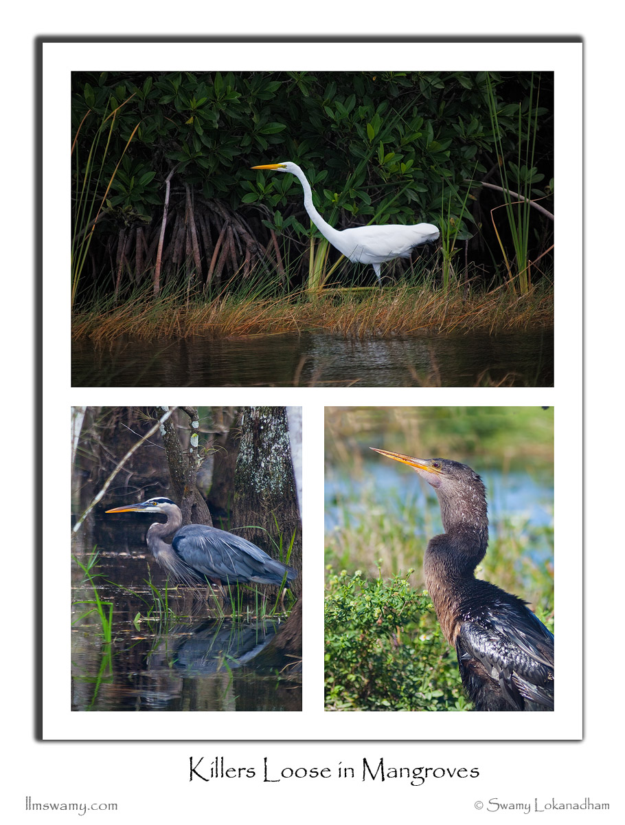
During dry season, water levels goes to few inches. Relatively warm weather and easy fishing attracts many birds to Everglades starting from December. Ample food sources and secluded habitat promote breeding in dry season. This is the best season to visit Everglades. There is only one road that goes through Everglade National Park. East entrance near Homestead is best place to enter the park to explore by road. However there are two other entrances to the park, where you can rent boat or kayak or take air boat ride to explore this fascinating preserve. Most of my images are freshwater marshes and Mangroves.
Top: Great White Egret
Left: Great Blue Heron
Right: Anhinga
Little Blue Heron
American Black Vulture
Turkey Vulture
Wood Stork
American White Ibis
American Alligator
American Alligator is the only wild alligator species left in the world. The only other alligator species that still exist is Chinese alligator. Chinese alligators are critically endangered and only known to exit in captivity. Although American alligators were at the verge of extinction in past, they are fully recovered and thriving around Gulf of Mexico now. Unfortunately, there are 20 other species in the park still listed as endangered including West Indian Manatee and Florida Panther.
Stray birds of summer come to my window to sing and fly away.
And yellow leaves of autumn, which have no songs, flutter and fall there with a sigh.
~ Tagore (from Stray Birds, one of my favorites from Rabindro)
Tagore heard a sigh in autumn leaves as they drop down. I hear a song of triumph and celebration of life in autumn leaves. Leaves in general, main source of food generator. At least for land bound animalia. Task well accomplished through the summer, as fall approaches, leaves of deciduous trees present their master piece to the world with shades of red. Autumn spectacle brings joy to the world. There is a grace and elegance as they finally drop down to ground to a slight fall breeze. A song of accomplishment, beauty and grace flow in the autumn air.
I’ve never been to Eastern Sierras in fall till this week end. I have been to Tioga Pass in mid October couple of times but never crossed to other side of the mountains. I wanted to shoot fall colors in the day time and shoot sunrise at little lake valley basin with Mt. Morgan, Bear creek Spire and Mt. Abbot in background. Drive to Mosquito Flat on Friday was nice. As I was crossing Tioga pass, I recognized that my beloved weather forecaster’s prediction of 0% change of precipitation on Friday yet again wrong. Strom clouds are looming on South Sierras threatening to rain anytime.
Here are images right out side east exit of Yosemite.
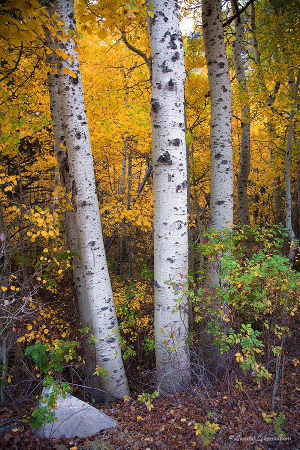
Eastern sierra elevation varies approx. from 4000ft. and to tree line and above. Fall colors change starts early at higher elevations starting around late August and continue till November at lower elevations. I knew that June lake area, which is known for best fall colors in eastern sierras is at it’s peak. So I took small diversion from highway 395 and covered 15 mile loop. I did not stop to explore the area, as I was getting late to reach Mosquito Flat camp grounds. Aspen grove on the Junk Lake loop are at their peak, shimmering in gold.
I reached Mosquito Flat with faint twilight is all left. I quickly found a spot and pitched tent and started cooking diner. It started drizzling. Mosquito Flat is at 10,250 ft. elevation. It is the highest designated trailhead in the Sierra, where you can drive. By the time, I finished my dinner and got into tent, drizzle turned into rain. Autumn rain at 10,000 ft. is pretty cold. It rained through out the night. Fist time in my entire wilderness experience, I shivered in my 13 degree Fahrenheit down sleeping bag in the night. I wore my jacket and gloves, but still was cold. While I was preparing dinner, I left tent flap unzipped. Sleeping bag got slight wet. Although down based sleeping bags are lighter in weight for same rated synthetic bag, when get wet, they lose their loft so their ability to keep you warm. On top it, my air core sleeping pad got flat. Despite all that I had good night sleep. Back in my mind, I knew I have my car 100 yards away in case cold is unbearable.
Got up at 5AM and hiked up to Marsh lake. It’s an easy 1 mile hike. Even though stopped raining, cloud cover was pretty thick. My hopes of seeing alpine glow on Bear Creek Spire is gone as it passed sunrise time. At 9:00 AM clouds cleared a bit allowing me to shoot this image. But with in 15 minutes, clouds covered the mountains again and started drizzling.
(Click on image to see large)
There are some back country camp sites at Marsh lake. But one needs wilderness permits to camp at these sites. So next time, I will camp right next the lake to avoid 1 hours hike in the cold. I wanted to go up further and check out the trail for better compositions for next time. After contemplating, I err on the side of caution. Stormy weather and improper sleeping gear can put you in tricky situation. Mountains are unforgiving to unprepared visitors.
Fall in Sierras is not all about Aspen groves and bright yellow color. In fact most of the color is close to ground. Grass and brush change color dramatically.
Here are few images …
(Click on image to see large)
While driving back home, took this image with familiar deserted home on highway 395 with dramatic clouds on mountains.
“The two most important days in your life are the day you are born and the day you find out why.” —Mark Twain
Finding purpose of life is a journey. Every individual need to discover their own paths and find their passion. People who can pursue their passion not only makes difference in their own lives but inspires others as well.
Here is one of such inspirations… Hakan Yalcin
Hakan is very accomplished mountaineer. He summited several mountains all over the world including dozens of Sierra-Nevada peaks. He has commendable knowledge on Sierras peaks and geology. I was fortunate to hike Glacier Canyon with him last year (trip report can be found few posts below).
Here is one of Hakan’s recent trips… Summiting Grand Teton.
Tetons range is part of Rocky Mountains that are spread from New Mexico to Canada British Columbia. Teton range is very photogenic range located in Jason Hold, Wyoming. During my two trips to Tetons National Park, I had opportunity to shoot Sunrise with Tetons in back ground. But looking at Grand Tetons craggy terrain, climbing it would have never crossed my mind.
Here is Hakan’s photo journal of Climbing Grand Tetons…
https://picasaweb.google.com/sierrawolf/GrandTeton201502#slideshow/6197164867615760914
To youngsters in audience …
Being inspired is good thing but, as Ben said (Benjamin Franklin), “If passion drives you, let reason hold the reins”. Class 5 climbs are technical climbs that need professional training and lot of experience. Just don’t take rope and cams to attempt rock climbing tomorrow. Attempt like this needs years of preparation and gradual built up of experience 🙂
Today (9/2/62015) is Super moon Lunar Eclipse. It’s called super moon since moon’s orbit gets closer to earth, thus it looks slightly bigger than usual. I went to Don Edward Wildlife Refuse in Fremont to shoot the total eclipse sequence. Unfortunately, clouds covered east completely. So I could not even see moon rise. But north and west were clear. So we had gorgeous sunset.
I had hardly 10 minutes to pick a location and compose this image. When fast flowing stream merge into slow moving (opposite direction) or stagnant waters, whirlpools are created. If you slow down your shutter speed significantly (15 sec. in this case), you can create concentric circles as you see in this image. You can see lion’s eyes, nose in the water with cattail (grass) as mane.
I came back home and found there are no clouds in San Ramon and I could see moon clearly. I missed total eclipse and so called blood moon phase. Here is what I could capture last one hour.
Bristlecone Pine trees that grow at about 10,000ft elevation are longest living non-clonal organisms in the world. Current oldest (known) living tree is over 5000 years old located in Ancient Bristlecone Pine forest on White mountains in California eastern sierras.
My friend Saket proposed a overnight trip last weekend (9/12/2015) to White mountains. It might be our last new moon day this year before winter set forth in Sierras. New moon days are excellent time to photograph night skies. There isn’t better subject than ancient bristlecone pines to compliment mysteries heavens. It’s insane 350 miles drive to White mountains with opportunity to shoot one evening. As Marilyn Monroe said, it’s better to be absolutely ridiculous than absolutely boring. As long as passion does not turn into obsession and overpower your will, little craziness fuels the zest in your life.
We reached visitor center at 5:30PM on Saturday evening. We wanted to check out Patriarch grove, which is another 12 miles, but it was wash boarded dirt road, climbing another 1000 ft. to total of 11,000 ft. elevation. We could not drive faster than 15 to 20 mph. After driving 9 miles, we realized that there isn’t enough time to go further before sunset. Idea is to find nice composition with a tree that shows some character.
Here are couple of images just before sunset.
Sunset wasn’t great. Southern skies were covered with nimbus clouds. Milky way comes up in southern sky in northern hemisphere. Best time to photograph milky way is between June and September in northern hemisphere. There are several apps (both on IOS and Android) that can guide to check out best time of the year for rest of the world. We can see milkyway throughout that year but September to June, we can see part of the galaxy that is not very bright. So not great time to photograph the milkyway during that period. We could not find a good composition to shoot Milkyway galaxy. As sun went down the horizon, we resorted to the tree in Methuselah Grove that I photographed couple of years back. We drove back to Methuselah grove, which is right next to visitor center. This tree is just about 1/4 mile from trailhead. By the time we hiked up, clouds disappeared mostly. It was pitch dark, perfect for night photography.
Here are some brief technical details on how to photograph milkyway galaxy. Photographing galaxy involves three step process technically. Artistic side, choosing the subject and composition to convey interpretation is personal choice. First step is to shoot sky in complete darkness. This requires a very fast lens; f2.8 or better. Even at largest possible aperture, it is difficult to capture sufficient light to expose galaxy. At wide opened aperture, there are two choices to increase exposure. Slowing down the shutter speed or increasing ISO. If you slow down the shutter speed more than 30 seconds, stars show streaks due to earth’s rotation. So set shutter speed to 30 seconds. Even at 30 seconds exposure, light will not be sufficient. Change ISO to 3200 or even 6400. Even with a good DSLR, beyond ISO 800 introduce lot of noise in the picture. There are several techniques to reduce noise, like enabling long exposure noise reduction in camera or using one of several noise reduction softwares in post processing. Second step in the process is to shoot foreground. Light the foreground with good flash light. You should take this shot at same aperture and shutter speed. Reduce ISO to 200 or even below. While shutter is open, switch on the flash light to illuminate the foreground. You do not need to keep the flash light on as long as shutter is open. take several shots keeping falsh light on for different lengths of time; till you get correct exposure. Third step is at home processing these two images. It’s very simple. Stack these two images together in Photoshop and choose blend mode “lighten”… you will see well exposed foreground picture with gorgeous galaxy behind together. Note that you need to use tripod while taking these two images. If you are interested to know more and have any questions, you are always welcome to send me an email. I’ll respond back with what ever information I know.
We met Christopher Eaton at the tree. He is professional photographer from Colarado. After introductions, Chris suggested that we coordinate together such that we do not ruin each other shots by flashing unwanted light into other’s shots. He brought excellent studio lights with him. Without his lights, foreground would have been as clear and bright as it came out. We spent upto 11:30PM shooting galaxy and star trails, until coulds came back indicating it’s time to say good night.
Here are the images from that night (click on image to see large)
We drove back to Bishop for the night. Next morning, we were so tired, did not bother to go back for sunrise. We drove back home.
A cup of coffee at twilight, at peaceful alpine lake that is reflecting a mountain range which is shimmering in alpine glow? My price for such experience for 5 days was 49 miles and 9800ft. climb.
Although my attempt to complete John Muir Trail this year is foiled by wild forest fires, wilderness experience was amazing as always. I set out on August 16th 2015 with 12 days, 110 mile hiking plan to finish the trail from Muir Ranch Trail to Mt. Whitney and eventually to trailhead at Whitney Portal. Unfortunately I had to exit the trail on 4th day into the trip, as rest of the trail was impacted by Rough fire smoke. Reaching end of the trail is never my intention. My goal is to experience the journey and mountain scenery along the trail. More than the destination, I want to remember the journey. I do not want to walk the trail for the sake of “finishing” the trail. I’ll go back to the trail next year to experience rest of the trail.
Here is map that shows where the fire is burning vs. my route
I wanted to publish trail journal for entire JMT together, but since this trip is short, I publish it anyway. Here is my day to day journey…
Day 1
Vermillion Valley Resort hikers van picked me up from Fresno Hotel at 8:00AM. We picked up my wilderness permit on the way at Prather. Ranger briefed me on usual wilderness rules and wild fires. She told me that no fires are in my way and nothing that I need to be concerned about. After 3 hours of driving, van dropped me off at Florence lake at 11 AM. I was happy to be back at Florence. There is nothing but a small store that operates boat across Florence. Next boat was at 12:30PM. I gulped two ice cream bars as waited at the store. Once boat leaves the dock, it will be long before I can taste any thing yummy again. Two rangers came from other side of Florence. We had short chat and they left as their ride arrived. I crossed Florence and started the hike at 1PM to Muir Ranch.
Florence Lake is at 7300ft elevation. Trail climb 500 ft. immediately and flattens till Muir Ranch. I met a couple and JMT Yahoo group co-moderator John Ladd at Muir Ranch. I spent about an hour and took off for Piute Creek. Just another small elevation gain but it was nice 3 miles hike next to south fork of San Joaquin River and Mt. Henry
Here is an picture on the way
I crossed Piute Creek and entered into Kings Canyon National Park. I camped next to Piute Creek below Pavilion Dome.
Sunset illuminated Pavillion dome
Over all about 900 ft. elevation gain and 8.5 miles hiking today
Day 2
Broke camp at 10AM. Sun was harsh already. Predicted high was 100 degrees that day. Trail continued next to south fork of San Joaquin River, climbing very gradually.
I followed San Joaquin until Evolution Valley, where Evolution creek drains into San Joaquin River. I left San Joaquin and followed Evolution creek upstream and started to climb up switch backs. It was intense. But Evolution Creek has numerous cascades made the effort worth.
Here are few Images
I crossed Evolution Creek before Evolution meadows. This creek crossing on JMT is considered dreadful in normal snow years. Lot of planning revolves around the creek crossing such that it is crossed early in the morning while water levels are low. California is under serve drought since last four years with worst/least snow fall last winter. So this so-called dreadful creek crossing was merely few inches above my ankles.
Here is the picture of the creek. You can search YouTube for Evolution creek crossing to see typical water levels of this creek.
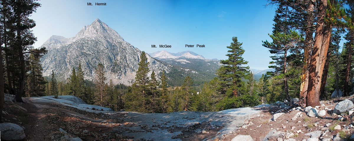
After few miles hiking, I reached McClure Meadows. It was so beautiful. I wanted to camp there. It’s great place to shoot sunset and sunrise. The meadow might see lot of wild flowers in early to mid July. It is worth paying a visit during that time. McClure attract more people and get crowed as well. 10 tents at one place is called crowed in wilderness. I did not stop at McClure and continued further about 2 miles and camped right at foothill of Mt. Hermit. It was great place.
Here are images of Day2 campsite (taken in the morning of Day3)
I hiked about 10 miles today with about 2000 ft. elevation gain.
Day 3
Broke camp at 9:10AM. It was a big day. I crossed Muir Pass and reached close to Big Pete meadows. Effective elevation gain was about 3100 ft. with 12 miles hike. As I left campsite, trail immediately started climbing towards Evolution Lake. Mt. Hermit and Evolution valley were in sight for some time.
Eventually I crossed Evolution Lake, Sapphire Lakes. All the mountains in this region are named after scientists worked on Theory of Evolution (click on images to view larger)
.
I crossed Wanda and McDermand Lakes before reaching Muir Pass. Muir Pass is 11,955 ft. The pass is on saddle between Mt Solomans and Mt. Warlow. Sierra Club built a stone hut in 1931 and dedicated to memories of John Muir. It’s shelter for hiker who may stuck on the pass during bad weather. We cannot camp in the hut itself in fair weather conditions. I want to camp near the pass next time so that I can photograph Muir hut with Milky-way galaxy.
Sitting in front of the hut, you can see Evolution range and Black Giant in front yard. Mt. Solomons in backyard.
I spent about 45 minutes in the hut and started descent into Le Conte Canyon. I dropped down to Helen lake at 11,600ft. and things changed dramatically. I started to see and smell smoke strongly.
From Helen, I caught middle fork of Kings river and started descending into Le Conte Canyon. With in few minutes, I met a hiker coming in opposite direction. He delivered the bad news, “Rough fire is gaining ground, 0% contained so far and the trail all the way till south of Forester pass is under smoke”. He told that on ranger recommendation many of the south bound hikers exiting via Bishop pass. As I climbed down further, situation was very apparent to me. Mt. Langille was right next to the trail, but I could not see it. I came down as close as possible towards ranger station, so that I can get there quickly in the morning to assess the situation. I camped that night close to Big Pete Meadows. Night was miserable. My eyes were burning and smell made me wake up all night.
That day I hiked 12 miles with 3100ft. elevation gain
Day 4
Morning was much better. Smoke considerably reduced. Here is a view from my camp site.
While climbing down 4 miles to Le Conte Ranger station, I spoke to several hikers coming up from north. Everyone said it’s not worth going south any further. Ranger station is located at 8700 ft., where trail from South lake (bishop) joins JMT. Ranger told me exact same words that I have been hearing past couple of hours. Ranger posted this note on the trail.
Air was clean in the morning few hours until wind picks up and bring smoke. I could hike in those hours and take break rest of the day. But it defeats the purpose of being in the mountains. I cannot see and enjoy them in smoke. And with that pace I can not reach Wood Creek in two days to catch packer who is bringing my resupplies. Without them, I had to exit the trail from Kearsarge pass anyway.
Next steps become apparent to me. Trail from here to South lake is 12.8 miles with 3300 ft. elevation gain. It goes thru Dusy basin, over Bishop pass to South lake. Given the worst experience last night, I wanted to climb up as much as possible to escape the smoke. Dusy basin is familiar grounds to me. Kiran and me hiked this area two year ago via Bishop pass. We stopped at lower Dusy basin. But did not come down to Le Conte Canyon that time. Another long day, but climbed up all the way to Upper Dusy basin at 11,200 ft. Smoke persisted through out the trail, but not bad at upper basin.
I camped at upper Dusy basin lake.
Palisades are the first 14ers on the trail. I should have seen the full range on JMT. But from here, Mt. Agassiz, Mt. Winchell, Mt Thunderbolt and North Palisade should be visible. I can see Mt. Agassiz in haze, but rest of them are barely visible. Alpine glow on Palisades was great treat, despite of the smoke.
Night was cold and peaceful. Overall that day I hiked 11 miles with 2700 ft. elevation gain.
Day 5
Got up to clear skies and clean air. I could see Palisades clearly. I finished regular chores and started for Bishop pass.
With in an hour, I was on Bishop pass. Hakan suggested me over satellite communicator to leave the pack on pass and climb Mt. Agassiz. It looked tempting. It would be 1900ft. climb from the pass. First 3/4 on loose rock thru a gully and top 1/4 was on solid rock a class-2/class-3 climb. After reconsidering the situation, I dropped the idea. There were still lot of unknowns. I need a ride from south lake trailhead to Bishop. Don’t know how long it takes. Once I get to Bishop, I need to find one way rental car. If I get the car in time, need to find what road are open to get back other side of the mountains. So I dropped the idea and hurried down the pass.
On the way, I met Abraham. He has been in Sierras doing cross country for last 30 days. Hopping one lake to other and fishing. He is going back in for another 30days. We had long chat on his where about. Very interesting personality.
Small geology lesson. As you see Mt. Goode has cirque in below picture. It accumulate lot of snow durig winter. During thaw, water runs down the slopes and feed lakes. Northern slopes not exposed much to sun during summer, thus snow on northern slopes last longer. Over run from each lake at upper elevation drains in to slopes. If the flow encounter a basin, it creartes another lake and over flow from that lake drains into slopes again. It usually continues until water reaches a river.
You can see Sierra water shed pretty clearly as you hike JMT. Below picture shows South fork of Bishop creek starts at Bishop lakes (no lake above it) and drains into Saddlerock Lake. Next image shows Spearhead lake that is below Saddlerock. Spearhead lake drains into Long lake, which eventually drains water into South Lake. Bishop creek has three forks. South fork, Middle fork and North fork. Like south fork that drains into South lake eventually , middle fork drains into Lake Sabrina and north fork drains into North lake. All three lake outlets created Bishop creek. Bishop creek altimately flows into Owens River. This is typical water shed configuration in Sierras.
Here is 5th day trail
As soon as I reached South Lake Trail head parking lot, I saw someone pulling out their SUV. I asked for lift and they accepted. They just finished their hike from Onion valley to South Lake. That whole stretch was under smoke. They told me their horrible experience.
I could not find any rental car in Bishop or any town around. I stayed that night in Bishop in Hotel and rented one way car from Reno. Next day at 7:30AM, I took Bus from Bishop to Reno airport (Eastern Sierra Transit) and picked my car at Reno Airport and drove back home.
That concludes my attempt to hike JMT this year. Except the smoke part, this part of Sierras is wonderful.
Now that I landed back in civilization, I need to be more alert as probability of dangers increased 1000 times than that in wilderness.
Over all this trip statistics are 5 days, 49 miles with about 9800 ft. elevation gain.
Here is the overview of the trail that I traveled in this trip
“I saw the mountains, with grey veils down and songs seized
Mourning for burning forest and fallen comrades
Among the mountains, I stood with my arms wide open
Not as an emancipator of their anguish, but with empathy and understanding
Among the mountains, I stood with grievances
Not seeking a culprit, but solutions for animosities against nature
Among the mountains, I stood in guilt and self incriminated
Remorse itself is not a solution, but need your actions”
~ Swamy Lokanadham
I thank thousands of firefighters battling with Rough fire over last few weeks.
Mountains have been calling me as well, but my responsibilities at work and home were screaming much louder :). Finally it is time to show my allegiance to them and indulge myself with treats they offer.
As most of you know my endeavor that I started last year to hike and photograph America’s most beautiful hiking trails John Muir Trail. Last year, after hiking 110 miles, I exited the trail on 12th day from Muir Ranch Trail. A cautious decision due to my weight loss and slightly sprained back muscles. I’m going back this year again to finish the trail from where I stopped last year. Nothing changed much in the pack (still 45 lbs.) except food. I’m not carrying as many calories as I did last year, but carrying what I definitely eat. The challenge is higher this year in terms of elevation gain. There more number of mountain passes this year. All of them over 12000 ft. and some of them are notorious, including summating Mt. Whitney.
I’ll start my hike on Sunday to reach Muir Ranch (6 mile hike from Florence Lake). I’ll camp at Muir Ranch on Sunday to get acclimatized. I’ll be on JMT starting from Monday, 8/17/2015 and expecting to finish the trail on 8/28/2015.
You can track my progress at following link. It points my location live on map once in every 10 minutes.
You can stay in touch by send message thru same web page (click on message icon, web server send the message to my satellite communicator)
Here is all the planning that is required for long distance backpacking. I try to follow more or less day to day plan on trail, but some time, change as I go. Nevertheless it’s important to have a plan in hand.
During my last year (2014) John Muir Trail (JMT) journey, I made a list of beautiful places that I need to revisit to photograph. Top of the list (as I passed this area on 3rd day) was Cathedral Peak and Upper Cathedral lake. As me and Kiran climbed up Cathedral pass last summer, we were greeted by an afternoon thunderstorm on the pass. Slight rain continued till we reached Tuolumne Meadows that afternoon. So I did not get chance to photograph Cathedral peaks last year.
Being 7 weeks away from my JMT endeavor this year, I thought it’s high time to unpack the gear and field test in order to prepare for the hike. Cathedral lakes trail was unambiguous choice. Saket was interested in going along. After our first trip to Thousand Island lake, we haven’t done backpacking together again. I also invited my colleague Umkant who was eager to experience the wilderness through hiking and backpacking. He joined us with his 14 year old son Vinayak.
We all set out on Saturday, June 27th (2015) early morning 5:30AM. Our plan was to reach Tuolumne Meadows wilderness permit office by 10AM and seek permit for next day. Camp at Cathedral lakes on Sunday night and get back to trail head by Monday afternoon and drive back home. Only 10 walk-in permits are available to Cathedral lakes per day. Fortunately we got permits for Saturday itself. Once you get permit for one day, you can choose to stay in the wilderness how ever long you want. Daily permit quota does not apply beyond first day. You must however specify date of exit on the permit application. I recognized the ranger who helped us. She was the same person who helped me on JMT permit last year in Yosemite Valley. We had little chat on JMT. We four had nice lunch at Tuolumne Meadows Grill. Vegetarian chilly was fantastic.
We started at 1:45PM from Cathedral Lakes Trail head at Tuolumne Meadows.
At the trailhead… when they didn’t start hating me for bring them on this trip 😉
Trail started to climb almost immediately. Upper Cathedral Lake is 3.5 miles from the trail head and climbs from 8500 ft. to 9600 ft. elevation. I had lighter pack of 35lbs comparative to my JMT trip, which was 45lbs. So it was much easier to hike up.
On the way we met this familiar trail buddy … Marmot
Once we reached the lake, it took a while to figure out away around the lake to camp at appropriate location. I never used deet before as much as I used in this trip. Mosquitoes were pettry bad at Upper Cathedral lake. Thankfully, hooded jacket that covers hands neck and deet on face made it easy to tolerate them. As sun went down, mosquitoes were gone as well. We reached around 6PM at camp site. Pitched our tents and finished our errands like fetching water from lake to cock dinner, setup sleeping pad and bag etc…. But I had run for shooting sunset before I could cook my dinner.
Here is the sunset image.
I expected colors to change deeper shades of red as sunset progressed, but unfortunetely did not happen. I climbed down a bit close to lake shore and composed this image with super wideangle 14mm lense to shoot this scene with stars trails. It would have been spectacular.
I expected some wind to blow away the clouds to make skies clear such that star trails will be visible without interruptions. After waiting for 30 min. I dropped the idea and went back to the tent. Well, good excuse to come back to this place again.
I got up at 4:30AM to shoot sunrise. I expected alpine glow on Cathedral peak, at least partially. But didn’t happen. Seems I need to get to Budd lake to able to see Cathedral peak in alpine glow (thanks to Hakan for the suggestion). Budd lake is other side of Cathedral peak. Here are image from that morning.
It was pleasant morning with quiet lake and blue skies.
We had nice coffee and breakfast. Broke the camp at 9AM and headed towards to sunrise lakes. Our first stop was at Cathedral pass. As we started to move away from Cathedral peak, we came across a nice patch of lupine on edge of a large meadow.
Cathedral pass is at just about 10000 ft. elevation with spectacular views. Cathedral peak itself is not visible from the pass, but Echo peaks, Cocks comb, Voglesanag, Mt. Lyell and Mt. Mcclure can be seen from there.
Saket relaxing on the pass
We reached Sunrise High Sierra Camp around 2PM through long meadows. Sierra Penstemons are in bloom.
We saw plenty of lupins, Sierra Penstemons and Mountain Pride in bloom. Sunrise High Sierra camp (SHSC) is not opened for the season yet. We took an hour break as it rained. We met two 60+ year old PCT hikers. Their supplies did not reach Tuolumne Meadows yet. Instead of taking couple of days break off from hiking, they are hiking to Yosemite valley from TM. Very inspiring. Taking up 2700 mile hike at 60+ years deserves an big applaud. Me and Kiran camped at SHSC on 2nd day of our trip last year.
We left John Muir Trail at SHSC and took sunrise lakes trail at the junction. Trail climbed up about 200 ft. and leveled off. We hiked about 2.3 miles to Sunrise lakes for the night. We crossed larger lake and camped at smaller lakes. It was great place. Rain forced us to setup tents quickly and take an hour break as it continued drizzling.
Camp site was pretty neat, large site with fire pit.
We were treated with great sunset. But area was surrounded by trees. It wasn’t easy to compose a frame without distractions.
Woke up in morning. Did not bother to photograph sunrise. Just sat before the lake and enjoyed solitude.
Those are the kind of moments, I hike up to these places.
(Click on the image to view larger picture)
We broke the camp at 9AM and within few minutes we hit trail junction where sunrise lake trail joins other trail that goes from Tenaya lake to Yosemite Valley through Clouds Rest. We took Tenaya lakes trail. That climbs down 1100 ft. to Tenaya lake in 2.5 miles. As we climbed down, we had great view of west side mountains.
We reached Tenaya lake by 12PM.
Tenaya lake is right next to Highway 120. We took shuttle bus that runs between Olmsted point and Tuolumne Meadows lodge. Had lunch at Tuolumne Meadows Grill (another Vegetarian Chilly) and drove back home.
It was great trip with very relaxed pace. Great trail for beginers to gain backpacking experience. We hiked about 14 miles in 2.5 days with about 3000ft. elevation gain. I highly recommend this trail, particularly for those who want to get into backpacking world.
Here is our tracks and elevation profile of our trail.
My new year resolution this year was to climb Mt. Whitney. Mt. Whitney is the tallest mountain in continental United States (48 states out of 50; Alaska and Hawaii excluded) with 14505ft elevation. Alaska has 11 mountains that are higher in elevation than Mt. Whitney, including the tallest in North America, Mt. McKinley with 20320ft elevation.
Mt. Whitney hike need wilderness permits. During summer, every day 60 permits for back packers, 100 permits for day hikers are issued. Every year in February, permits are issued based on lottery. I was a bit disappointed when my application was not selected in last feb. I was still hopeful on cancellations, so kept an eye on permits web site (www.recreation.gov). I almost gave up my hope as October approaching, which brings strong winds and icy conditions on the mountain. Finally on September 13th, someone cancelled 6 permits for September 22nd. I grabbed 3 of them and with in an hour rest of them were vanished as well. So hike was set for Sunday, September 22nd and completes on following day (Monday ) evening.
Now that I got permits, it’s time to assess my fitness for the arduous task. It’s 22 miles hike with 6200ft elevation gain. Distance wise, just 4 miles longer than previous two trips, but elevation gain is almost double. Also it’s solo hike as all my hiking partners have commitments during September 22nd week. It was a short notice. In fact, I also have hard deadline to be back in office by Tuesday as a customer visiting us for rest of the week.
I started September 21st, Saturday afternoon to eastern sierras. Plan is to stay in Lone pine village that night and start my hike next morning. As I entered in Stanislaus national forest; I could see the damage caused by Ring fire last month. I took below panoramas with point shoot camera. Also see in the insert, how it used look prior to the fire. Fire destroyed significant amount of forest that I always cherished on my way to Yosemite valley. Don’t know how many decades it takes to restore back the forest.
It was raining throughout my drive, but as entered Yosemite, it started snowing. Exactly what I wanted to avoid in my hike. I went ahead anyway. As I crossed Bishop, Storm is cleared and found that there is no rain in lone pine at all. It took 8 hours to reach Lone Pine. I picked up my wilderness permits and WAG bag from night box at visitor center ( you need to make arrangement with rangers to leave your permits in night box). Inyo National forest instituted mandatory rule to pack out human solid waste from elevations higher than 12000 ft. So they provide WAG bags (waste alleviation and gelling) along with permits.
Mt. Whitney hike in summer done in multiple ways. Mountaineering route needs technical skills to summit. It’s class 4 or 5 climb. But people without technical mountaineering skill can do it two ways. Day hike from Whitney portal is more popular. You have to start your hike well before ( 2 to 3 hours ) sunrise to finish 22 miles, 6200ft climb by end of the day. Based on your stamina level, you have to plan for 14 to 16 hours on trail. Problem with this way is that you will be walking first few miles in dark, either during predawn or dusk. So you will not be enjoying this portion of the trail. But if your target is the summit, this is better option as you do need to carry huge loads on your back. I have chosen another way that is to backpack for two days.
On Sunday early morning, I went to foothills of Mt. Whitney ( This area is called Alabama hills and featured in many many Hollywood movies). I missed peak alpine glow on the mountain range while driving on dirt roads and fanatically searching for good composition. However managed to get this huge panorama with good light on it. I labeled the mountains for reference.
I started my hike from Whitney portal at 9am. Trail head is marked pretty clearly. There is a weigh scale to check backpacks for final time.
Here is map to the full trail
You cross several stream as you climb up from 8300ft to 10000ft in 2.6 miles to Lone pine lake. You need to take a short 0.1 mile stroll to lake shores. Permits are not required for hiking upto here, but for overnight camping needs permits.
You leave lone pine lake and enter in to Whitney zone here. Beyond this point permits are required and pack out human waste is mandated. Another mile on almost flat trail takes you to a beautiful meadows. Crossing the meadows you enter into outpost camp. This is one place some backpackers like to camp. If you are feel the altitude effects, this is just right place (10300 ft.) to get acclimatized.
Mirror lake is just 1/2 mile from outpost camp, a very picturesque location at 10600ft. However, camping is not allowed in this area.
From here trail is all rocky. You leave the trees below as climb above tree line. So no shade beyond this point. I headed to trail camp for the night. Plan is to summit next morning and return back to trail head by evening. So I can drive back 7 hours to home. Trail camp is located 2 miles from Mirror lake and still 1400 ft to climb. I wanted to plan tomorrow such that I can get down mountains (cross yosemite) before sunset.So I started asking returning hiker on where did they stayed last night and when did they started the summit and when they reached to summit. what I gathered from the hiker was a scary story of last night. It was snowing heavily and winds swept away many tents ( rain flys). 8 groups that stayed at trail camp (groups I spoke with) did not even attempt to summit in the morning. They said that they were so tired dealing with weather last night, so they slept in the morning and climbing down now. Such weather is not strange here; particularly in September. I prepared well for the weather and carried extra guyline to secure my tent. No preparation ever going to be adequate in nature anyway. I met many people who coming from John muir trail as well. They successfully completed summiting and were coming down with victory. John Muir Trail (JMT) starts from Yosemite Valley goes through many vistas and valleies and ends on Whiteney (200+ miles). I met atleast 5 people in this trip those completing their last leg of JMT…a life time achievement… bravo.
I reached Trail camp at 3:30pm. I setup my tent and socialized with fellow campers around.
At 6 PM, while I was enjoying hot coffee by the lake, We heard that a day-hiker at trail creest was seriously ill with altitude sickness. With an hour, we loose light and she is still another hour and half away from where we are and 6 to 7 hours to trail head (if she can walk at regular pace). we all concerned on what to do. I offered to leave my tent and sleeping bag for her and go back. But suggested that it would be better for her to continue to descend to trail head. We all concurred on that. We contacted the group that was assisting her over the radio and informed on what we are thinking. Some people offered electrolite and food. The group descended to trail camp at 8:30pm and continued to trail head. I was concerned a bit as terrian is very rocky for next coouple of miles, but moon came out so strong and illuminated the landscape very bright. So I hope they made it back safely. Next day I asked a ranger on way back and he did not heard anything about them. So news is good news in this case.
Even though I want people get on to these trails and get close to nature, I want to caution about altitude sickness also known as accute mountai sicknes (AMS). Elevation over 8000ft considered as high elevation and some people start to see affects (generally over 10000ft ) like severe headache, nausea and fatigue. The concentration of oxygen remain same at sea level and higher elevation, but due to decreased atmospheric presure, number of oxygen molecules per breath reduce to 50% (approx.). So in order to properly oxygenate the body, your need to breath more. But its difficult to supply same amount of oxygen as low elevations. If your body need more oxygen while walking, it makes situation further worsen. High altitude and lower air pressure causes fluid to leak from the capillaries which can cause fluid build-up in both the lungs and the brain. If any symptoms are observed, its advised to take it easy and wait an hour without any activity. If symptoms persists, its highly advised to climb down. The only reliable way to fight AMS is acclimatization for a day or two at moderate high elevation before assending higher. Listen to your body and act wisely. You should know fail safe situations. Never cross the thin line that separates self-determination and fanaticism. Ranger told me about a fatal case of AMS on Mt. Whitney three weeks ago.
Anyway, I had my dinner and rested in tent for the night. Had no mood for night photography. I carried my camera gear this time as well, but all the pictures except mountains panorama (taken from Alabama Hills) is taken with point and shoot camera only.
Night was quiet, no wind or snow. Two things that can go wrong on these mountains are weather and AMS. Nothing to worry about Sierra bears.
But again, do take right precautions. Bears does not reach 12000 ft. Thunderstorms are very frequent in this area and first sight of thunderstorm, its highly
recommended to climb down. I got up at 4:20AM and started my hike. Moon was still bright. It was pretty cold. I saw couple of headlights already climbing up on trail. From Trail camp its about 5.8 miles, 2500ft elev. to summit.
I regularly climb same elevation and mileage (mission peak) at home about an hour. Mission peak climbs from elevation 200ft to 2400ft elev. in 2.6 miles. It took 4 hours to reach summit. I took two hours to climb 99 switch back and reach to the trail crest. Just in time to watch sunrise.
Switchbacks (actually taken during my descend.
Just couple of minutes before sunrise
It was mesmerizing. Just about a day back, I was frantically searching to shoot alpine glow on these mountains and now I was part of the scenery.
I liked more west side valley with Mt. Hitch cock, Hitch cock and Guitar lakes. Excuse me for poor panorama stitch. I was shooting panoramas using point and shoot (which does not have panorama assistance feature) without tripod. This is the time, I missed my DSLR dearly.
Trail crest is at 13500ft. and 2 miles to the summit. I meet couple of happy faces climb up from west side at John Muir trail junction.
They knew that this the last difficult segment in the journey that endeavored 2 or 3 weeks ago. I heard many stories about how people take wrong trail at this point and go deep into wilderness instead of climbing down the Whitney at right side. I do not figure out, how people can go wrong with such a clear signage at the junction.
I was thrilled at my the first sight of Smithsonian hut on the Summit.
Finally at 8:20AM, I was on the top. Signed the prestigious summit register.
This is for my Dad. His love for forest and decades of public service in forest agencies of India are commendable.
I spent 15 minutes on Summit and started my way back. By 4PM. I was back at my car. It was long day about 12 hours on trail covering 16 miles. Unfortunately, my day wasn’t over yet. I had to driver 7 hours back to home. I was on Tioga pass during sunset. Mountains on Tioga are just decorated with very first snow (on Saturday) and meadows are simmering white with fresh snow. Alpine glow on mountains are so inviting. This is the kind of scenery that I travels miles and miles to photograph…but I have my targets to reach home in time for tomorrow. So I kept driving. Nevertheless, I really enjoyed both Whitney and Tioga pass this time. With last three backpacking trips this summer, I really experienced sierra for first time.
Again and again, I remembered John Muir’s book that read couple of years ago, My First Summer in Sierras.
Snow on Tioga marks, no more backpacking trips for this year (probably). I’m looking forward to take entire 211 miles John Muir Trail next summer (if I can take 3 weeks off).
Joshua Tree National Park is one of 9 national parks in California; located southern part of the state. It spread into two deserts, Sonora and Mojave. Unlike other national parks, there is no unique attraction in the park. This park attract visitors with two features, Joshua tress and outcrop of granite boulders.
As name suggests, Joshua trees are prevalent in the park. They sure remind you of Dr. Seuss books.
Sunset over Joshua tree forest
Other attractions in the park are outcrop of granite boulders. Towering over 100 ft., these boulders serve as training grounds for rock climbers. We have seen 100’s of climbers in two days. Climbing the boulders is one of the activity that kids loved in this park.
Here is star trails with Joshua Tree in foreground
This is image is result of 14 pictures taken in span of 1 1/2 hours. Each picture is of 5 minutes shutter speed with aperture wide open ( f2.8) and ISO 400. Stray light near horizon is caused by passing cars. I chosen location right next to the park road in order to have company. Image quality suffered quiet a bit from car head lights. As earth rotates on its axis, stars motion creates streaks when it’s recorded for long enough time. In northern hemisphere, earth axis goes thru Polaris (north star). So place Polaris in the frame where you want center of the circles.
Teddy-Bear Cholla is another interesting plant in the park. You can see them in Cholla Cactus Garden located in Pintos Basin, east side of the park. Couple of sunset pictures.
With some luck and apt timing, visitors can see endangered desert tortoise in this park. Rangers told me that high chances of spotting them is during spring or when it rains. They spend 95% of time in their burrows.
There are some more interesting spots in the park that we did not get chance to explore. Couple of days of camping in back country gives access to many interesting places here.
If you are planning to visit the park, don’t miss climbing up Ryan mountain.
I was ready for a lazy winter after finishing last of my three ambitions of this year, half marathon (13 miles/21 km run) to benefit San Ramon School District on last to last weekend ( 10/12/2014). Hakan came by with a proposal to hike to a canyon that has been in his to-do list for sometime.
Hakan is very accomplished mountaineer. he summited several mountains all over the world including dozens of Sierra-Nevada peaks. He has commendable knowledge on Sierras peaks, geology and watersheds. I have been waiting for such opportunity to hike with him in Sierras from long time. I had a week to recover from the run and have been physically active through out the year, so thought I’m ready to take any challenge that this cross country hike including summiting two peaks would present. Cross country hikes basically means no hiking trail to follow. You will make your own way towards the destination. It involves many track backs, retries and changing courses.
Our plan was to park the car at Tioga pass, hike to Glacier Canyon that features Dana Glacier and Dana lakes, climb north-west facing canyon wall towards Mt. Dana, Summit Mt. Dana, get down to saddle between Mt. Dana and Mt. Gibbs, Summit Mt. Gibbs, return to the saddle and follow the creek that flows down the mountains towards highway 120 and reach eventually back to the car.
Here is our planned route
On Friday 10/17/2014, we started around 7:30PM after work. Stopped one hour at Oakdale for dinner. Crossed Tioga pass around midnight and reached Lee Vining around 1AM and grabbed keys that are waiting by front door of our hotel. Lee Vining is a very small town right on junction where highway 120 connects to highway 395. Good place to stay for exploring Mono lake and surrounding areas.
I was pretty concerned about driving on Tioga Pass during the night as fog rolls in anytime making visibility pretty bad. We had very calm weather with almost all the road for us. We tried to sleep, but late night coffee took toll on us. We got up around 5:30AM and prepared oatmeal breakfast and got our packs ready and left for Tioga Pass.
Tioga pass is at 9,943ft. elevation. Yosemite national park east entrance station located right on the pass. We parked our car outside the entrance gate on roadside and started walking into wilderness around 7:20AM. We reached a small beautiful lake in about 0.3 miles.
Hakan marveling at the nature …
Sun raised over horizon, as we made our way towards the canyon entrance.
We crossed an unnamed creek that flows into Tioga Lake. We stopped at nice cascades for few minutes.
Just with in half mile in our journey, we found ourselves walking on talus. Eventually we reached the entrance of the canyon through nice meadow. What I did not know that point of the time was that rest of our hike will be on talus and moraine. Talus is basically heap or slope of rock debris. As glaciers move, they crush boulders in to small rocks. The talus we encountered is mostly 1 to 3 cubic foot large. Moraine is combination of soil and very smaller rocks grinded by glacial movement.
Canyon floor was like a staircase of about 4 steps. Each step has one or two lakes. Purity or clarity of water improved as we go higher and higher. Lakes started to freeze already. The thin lines you see in below picture in foreground are frost layer formed in the top. Its still very thin and fragile, but as winter approach these lakes will freeze. You can see ice formation in the insert in below picture.
Here are couple of pictures of the canyon and lakes …including its visitors
Looking back the way we came
Hakan looking at Dana Summit.
One of the clear and pure lake I ever saw. I did not find even algae that grows on the submerged rock on the edges of lake.
Hakan filling the water bottle directly…no filtration required.
We finally reached the end of the canyon and Dana Glacier…Still holding up… never know how long…
Hakan inspecting the glacier … see him in the insert that gives perspective on size of the glacier.
Looking back at way we came. We had a great view of Mt. Conness, North Peak and Shepherd Crest.
We surveyed east side canyon walls that we supposed to climb to get access to summit Mt. Dana. They are pretty steep and treacherous. We found north side wall to be reasonable. We decided to climb up to Dana Plateau and thought of negotiating our way to the summit over canyon ridge. That’s when my troubles started. Canyon wall rose about 900 ft. over about 0.25 miles (1300 ft.), i.e. 77% grade. Its class-2/class-3 climb over loose talus. Hakan took my camera that was hanging over my chest and blocking my vision. We took support of rocky outcrop and slowly climbed over to Dana Plateau. It nearly took 2 hours. I was completely exhausted. Based on pure distance and elevation it was like a simple stroll compared to what I did on JMT with 3 times more weight on my back. But walking on talus, minding every single step and pushing up the body higher as you climb was entirely different. Half marathon was much easier for me than this. Based on time and my energy levels, we decided to drop out Mt. Gibbs or Mt. Dana from the list.
Here is the Google earth profile of the wall we climbed.
We walked over to ridge that connects Mt. Dana and Dana Plateau. To our disappointment, the ridge is very narrow. We climbed over to rim but could not proceed further. At that time, we had to conclude our pursuit of finding route to Mt. Dana from Glacier Canyon. But views from the ridge were breath taking. Here is the panorama of east side.
You can see complete Dana Plateau, Mono Lake and Mono craters.
More pictures
We walked along the Dana Plateau and came down to the canyon entrance but other side of the creek, where we found a trail that led us to Tioga Lake south end. We reached highway 120 and walked along the road to reach our car. We walked abut 45 min. in the dark. Over all, we hiked 12 hours about 9 miles with 3500 ft. elevation gain.
Glacier Canyon is fantastic and Views from Dana Plateau are extremely beautiful. Many lessons learned. My camera harness was really bad for off trail excursions like this. Walking on talus is no fun when you can not see where your foot is going. Running and hiking need their own training methods. I need to get down from tread mill and get back on to stair case mil again.
John Muir Wilderness lies in Inyo National Forest and Sierra National Forests. It’s home for some of the beautiful and tallest peaks of Sierra Nevada including the tallest mountain in the continental United states (48 states), Mt. Whitney. Me and my friend Kiran did two day backpacking to Dusy Basin, one of the fantastic areas in the wilderness.
Trail starts at South lake at 9800 ft. Trail quickly climb to 10760 ft. in 2 miles where it meets Long lake. As aptly named, Long lake is narrow but about 1 mile long. Next one mile of the trail pass next to Long Lake. After that trail climbs about 200 feet passing Spearhead lake and Timberline Tarns. Trails passes next to very beautiful Saddlerrock lake (and a tiny ledge lake) and Bishop lakes before climbing up over 1000ft in less than mile through several switch backs to Bishop Pass. Bishop pass is at 11972 ft. elevation. Due to harsh conditions, serve snowfall and wind, tree does not grow at this elevation. First sight of Mt. Agassiz, Mt. Winchell, Thunderbolt peak and North Palisades let you out a involuntary scream of joy. Upper Dusy basin is good for photographing Palisade range. Next 3 miles, we climbed down 1400ft in to lower Dusy basin. Its spectacular place. From last two trips, I realized that two day backpacking is not enough to explore these places in detail and photograph.
We hiked about 18miles in two days with 3500 ft. elevation gain. This trail is in and out type (means you will return on same route as you went in).
Here is the detailed map. I recorded GPS tracks for this trail, I’ll upload GPS tracks here for download.
In the night, when you lie on your back and look into the billions of stars in clear night skies; away from pollution and city lights; you can’t stop think about vastness of university. We look minuscule among countless galaxies, their billions of stars and solar systems. Yet, we are lonely planet and silent observers; so fragile and vulnerable for cosmic calamities. Despite the fact that there is no other place as alternative, global conservation efforts are merely a debate in many countries. Anyway, back to trip report. Two nights that I was in wilderness, I spent couple of hours looking at the sky and shooting Milky way galaxy.
On Friday, we left for Bishop (small town in Sierras, California) early morning so that we can pick up permits for the hike and get acclimatized to high elevation. That night we went to Ancient Bristlecone Pine Forest on White mountains. Bristlecone Pine trees here are longest living things in the world (over 4500+ years). Here are some pictures from this trip
Here some other pictures (These images are not in the gallery )
Sierra Nevada mountain range in California is one of beautiful ranges in the country. It is home for lake Tahoe, the largest alpine lakes in North America and Mt. Whitney, the tallest mountain in contiguous United States. Three national parks Yosemite, kings canyon and Sequoia created in this region. There are about 20 designated wilderness areas in Sierras. Ansel Adams wilderness is one of them.
Last weekend, me and friend Saket Jain decided to experience the Sierras in Ansel Adams wilderness. We did backpacking trip to Banner peak and Thousand island lake. We hiked 18 miles( 29 KM) in two days covering Thousand island lake, Emerald lake, Ruby lake and Garnet lakes.
Here is our trail map.
We started from Agnew meadows trail head and took river trail that runs next to San Joaquin river. One the way up, we were surprised with unprecedented thunderstorm, rain and hails. I was excited. People who know me long enough know how much I love rain. I was also excited since clearing thunderstorms leave a great clouds behind. When we reached to thousand island lake, prospects for great sunset was evident.
It’s back country, so no developed camp ground. Just find a flat surface and call it your place. However wilderness camping rules prohibits camping up to 50 ft near to lake shores. We scouted around and careful chosen our spot based on proximity to the area we possible shoot our sunrise. Alpine lakes are pristine beauties. Clean and calm. Quietness at high altitude ( thousand island lake is at 9850ft ) eliminates distractions and brings peace. Here are some images just an hour before sunset.
As sun dropped down to horizon, clouds moved away from Banner peak. We had to abandon our plan to shoot Banner peak and turned around towards east where sky is more interesting.
Thanks to our good planning, night was comfortable. High elevation brings cold nights. I was prepared with right stuff for the weather. Typical light weight overnight backpacker carries about 30 lbs (14 kgs) of stuff. After all efforts I could not reduce my pack less than 40lbs (18 kgs). 10lbs accounted for my camera gear itself. I bought ultra light tripod and took only 17-40mm and 24-105m lenses.
Sunrise was good. No clouds around Banner peak though. It wasn’t as cold as I was expecting. Around sunrise time, smoke from Fresno wildfire (70 miles south-west) blew right around Banner effecting contrast and color. Here are some sunrise pictures.
John Muir trail that starts from Yosemite passes through the thousand island lake. 211 miles of John Muir trails passes on many alpine lakes and Sierra peaks. On our return, we took John Muir trail. Our initial plan was to go down till Shadow lake on John Muir trails and connect back to River trail. As we hiked up to Garnet lake, we were able to smell the faint smoke in the air and fog-ish conditions were blocking farthest views. So we decided to go back to River trail from Garnet itself.
Here are few pictures on trail. Over all, it was great trip and splendid experience. Saket and myself looking forward for our next trip in this summer in Sierras.
Washington’s three national parks, Olympic, North Cascades and Mt. Rainier are state’s crown jewels. Olympic National park is way different than other two. It has Olympic mountain range, temperate rain forest and beautiful coastline. Olympic range is actually not very tall. Tallest among them is Mt. Olympus, about 7980 ft. high. Due to high precipitation, this range gets lot of rain and snow. This range hold many many glaciers. Hurricane ridge provides excellent vista points to see this range. Subalpine meadows of hurricane ridge display grand show of wild flowers in summer.
Here are some images from Hurricane ridge.
I originally planned for a road trip across north-west coast all the way from San Francisco to Washington tip. My kids joined me on this trip. Considering only 5 hours drive a day, it takes away 6 days for to and fro journey. So dropped that idea and flew to Portland, Oregon. From there we drove around to all these national parks. Our first stop was Port Angeles, Washington. It’s beautiful town. Vancouver Island, Canada is just a ferry trip away from there. Hurricane ridge is 17 miles from Port Angeles. Good thing about Olympic national park is that you can avoid expensive national park accommodation and still be reasonably close to the park. Next day we covered Sol Duc and Lake Crescent areas. Sol Duc river and Sol Duc Falls has good hiking trails. Sol Duc also has hot springs area. Unfortunately these hot springs converted in to spa pools; but other hand, it’s much safer for people to enjoy goodness of the hot springs.
Here are some images of Sol Duc Falls and Sunset at Lake Crescent.
We stayed in fork for three days. fork is small coastal town outside Olympic. But this is central place to go either Sol Duc, Hoh Rain forest and all the beaches. All the rain fall due to Olympic Range, created two temperate rain forests at foot hills for the range. Hoh Rain forest and Quinault rain forests. Next two days we spent in Hoh Rain Forest. Photographing forest scenery is very challenging. Composing the frame without distractions and still maintain your story is great learning experience as artists. Presence of mind is always required but here you cannot do without it. If you want to challenge the artist in you, this is the place to take it. Its really fun. My kids were unusually cooperative in this trip with my long stop overs for each picture I took. Some reason, I did not get same privilege on first day in Hoh rain forest. So we came back hotel early and watched nice movie.
We spent another day in the rain forest….dropping out Quinault from our list. Weather was great in the rain forest both days. overcast with slight rain. Ideal for photography. We fortunately carrying our rain ponchos with us. I would now suggest a mosquito repellent spray as well. Obviously, I realized why kids were a bit cranky last day, only after seeing bumps caused by mosquito bite on their hands and forehead.
Fox Glove flower are in full bloom everywhere. Here are some images from Hoh Rain Forest.
Last day we spent in Ruby beach. We had blast playing in the beach for long time. After getting them back on dry cloths, I spent sometime composing some images. sky was promising with great cloud cover, but unfortunately, not that great show of color at the end. There are so many other beaches in this area with great sea stacks (mounds). La push and second beach are two other beaches, I wanted to cover, but did not get chance this time.
Next day, we took off to Seattle. We spent one day in Seattle Science museum and Space Needle. Next day we took off to North Cascades National Park. North Cascades and Rainier are part of Cascadian range that extends from Lassen peak in North California to Canada’s British Columbia. These volcanic mountains are part of pacific ring of fire.
North cascades is less known and less visited national park. However, I found it pretty good. Beautiful Skagit River with greenish water runs next to Route-20 that takes us from I-5 to North cascades. National Park boundary start from few mile further on Route 20 from Marble mount village. But I fell in love with cascade river road that starts from Marble mount village into north cascades. First few miles are paved and rest of the road is rough, patchy and very narrow; but you can travel by even a passenger car as well. Cascade river runs along next to road. You can see cascades (Mt. Johannesburg, Cascades and Magic Mountain and Mount Formidable much closer. Cascade pass trail starts at the end of the road. Route 20 goes through North Cascades National Park. There are several waterfalls and lakes on the way. Gorge Falls and Diablo lakes as well.
Here are some images
We stayed in wooden cabins in Rock port. These wooden cabin are great. With kitchen and fire place, kids enjoyed homemade food after a weeks fast foods. From there we took off to Mt. Rainier next day. We reached a bit later than expected. We could able to cover some hikes and water falls before reaching paradise. I love Mt. Rainier. My both the trips to Rainier are little early in the year to see wild flower spectacle there, but still there are lots of flower in bloom. The grandeur of Mt Rainier always amazes me. Sunset and Sunrise was great from reflection lakes. I did not get lot of time to compose my images here. When I was waiting for sunrise last year, clouds covered Rainier completely. But while clouds moving, I had a very brief peak of alpine glow on rainier. It was bright red. This time, weather was a bit warm and no clouds. I did not see same color during the sunrise. But anyways, it was fantastic morning and a great trip.
In my long drivers, whether I’m entering into Humbolt county (Redwood National Park) or nearing Sierras, I always feel an awakening. Something like, I woke up from trance. Anticipation fill my heart. I wish my communication skills go beyond talking through images, so that I could express them in words.
I went to Tioga Pass this weekend. But this time, for some reason; I did not feel that I’m at subalpine environment. I was on Tioga pass during mid-day; that could be the reason I did not enjoy it that much. It was much better from Tuolumne Meadows to Yosemite park exit. Tuolumne river is flowing at very low levels. No signs of flowers in meadows and very few patches of corn lillies here and there. We only stopped at couple of places very briefly.
We went to Monlake for sunset. South Tufa area is best place to see monolake unique geological feature tufas. This area is more photogenic than other places around monolake. Drive 3 to 5 miles north towards Reno for complete view of the lake.
Sunset was spectacular that day.
We also shot sunrise at the same place. You can see alpine glow (left to right) Mt. Lewis, Mt. Gibbs and Mt. Dana.
Misson Peak along with few other places in the Bay Area is prime location for hiking. Summit at 2500 ft elevation offers a great view of silicon valley. An early morning (an hour before sunrise) trip to the summit greets with refreshing fog at foothills. As you climb up above the fog, spectacular scenery with dawn skys and cloud cover over the valley from Mission peak to Santa Cruse mountains mesmerizes the hikers.
Since my first climb few years back to now, traffic on trail increased dramatically. Even though I’m pleased and applaud the increased health consciousness in people, I constantly see some of us take short cuts and make new paths to the summit. These actions will result into land errosion and damage to already minimal flora.
Volunteers and Rangers are ticketing people caught on these short cut paths, but I believe the change should/will come from individual’s self-conviction. Current state of peaks does not look threatened, but hopefully we never get to that state.
Land preserves meant to preserve them to their natural state. I wish cattle are not allowed on the peaks.
Image (Mission Peak on right corner and Mt. Allison on Left corner)
Click here to go to gllery directly.
For last four year, I went to Yosemite many time during February in hope to see the magical light transforming tiny, thin horsetail fall into hot streaming fire falls. Finally it was my turn to witness this magic. Generally anticipation makes expectation bars rise higher. The longer you wait eagerly, higher your expectations rise. So in general when things happen, you end up with little disappointment. But in case of horsetail falls it was beyond my all expectations. I have been seeing many photographs over the years. I almost know every streak and stain on El capitan around the falls. In spite of that my heart pounded as the light shifted towards peak on red spectrum and water flow shimmered in light.
As I mentioned in my journals last couple years, the original photograph was taken by Galen Rowell.
His image of this falls is still the best. You can see it in Galen Rowell’s Yosemite gallery (2nd page)
My image is from some where close to Cathedral Beach on South Drive.
As the color on falls slowly faded light, my focus turned towards the sky. Sunset was glorious.
Unfortunately there are lot of distraction in left corner in this image (below). Had we got enough time to get into the river, it would have been a great image.
We enjoyed sunrise at inspiration point. Following two images are from there. Point to note here is
First image was taken 30 minutes before sunrise, Peak color faded away with in a minute or two. So I guess, we need to be there way before sunrise here.
Following two are my personal favorites from the trip. This is one of the intimate images of Merced flow. I had to get into water for right perspective and zoom for this image. I had waterproof over-all on me, without which I wouldn’t even dare touch winter cold river. Merced is cold even in mid summer.
Here is another original and personal favorite “Life Under Shadow of Giant”.
After weeding through multiple cancellations and postponements for a month, I finally took off on 4 day trip to Death Valley National Park on Thursday, Nov 11th. Its basically two full days in the park that’s as large as 1.5 times of delaware state; good luck.
I spent most of the time at four places only.
Two important playas (Playa means flat-floored bottom of an undrained desert basin.) in the park,
Salt Flats
Race Track.
Mesquite Sand dunes
Zabriskie point
I spent quality of time at each location and the experience at each location was exquisite. Name of this national park turns some people off, but the beauty that this place offer to its visitors is exceptional…Soaring temperatures in summers often cross 120 degrees Fahrenheit reminds the name is apt.
Salt ponds at bad waters: This is lowest point in North America, 286 feet below sea level. Mount Whitney, the highest point in the contiguous 48 states is 85 miles far from here. Bad waters located 27 miles from furnace creek village.
I spend two sunsets here. Sunsets behind telescope peak (range), but you can turn any side that has good composition and sunset colors…that’s big advantage at this place. Just walk straight into salt ponds about 1 to 3/4 miles from parking lot for good undisturbed formations. Alternately, drive little more distance from parking lot and park on the road side and walk into the flats to avoid crowd.
Here are couple of images from this place. Click on each image to view largers
I stayed back after sunset to try star trails. I started clicking off one hour after sunset. I took 16 images in next two hours. More images makes skies more interesting…but I wanted to see how successful is my attempt first, before committing another hour or two in the night. I was the only one around in the salt ponds, three hours after sunset, no sound other than wind. Even though it was half-moon in the sky, it was reflecting off the light from complete white fields and sky with full of stars…its just pure beauty. Close your eyes for couple of minutes. Open your eyes and look around you. I’m not trying to be more poetic here, but an experience that this moment brings will stay for ever. At least speaking of me, it will.
This image shows how bad my star identifying skills are. My intention was to put polaris in the middle of the frame. Obviously I missed it big time. My exposure was also not correct. On top of all these, there were couple of passing clouds in the two hour period brought some noise at horizon. Anyways, for second attempt…not bad at all.
Race Track: Its a ancient lake bed. Its 32 mile drive on very rough dirt road from Ubehbe crater. A high clearance vehicle is required. 4 wheel drive is preferred, but not necessary. Inspite of engaging part-time 4 wheel drive, I did not drive more than 20 miles to ensure, my tires are OK. Rocks in this playa are moved slowly making their way marked in the clay promptly. It’s believed that this rocks are moving due to wind. I reached here 3 hours before sunset and surveyed the area and picked up my racing horse…na…rock and waited. I tried star trails after sunset. This was my first attempt and missed on exposure, position
completely. But again, experience at this location is great. No one around you for at least 40 miles distance. Whole playa, sky and stars are all yours. Pure wilderness experience.
I camped in a primitive campground two miles away from the playa for the might. This camp ground is not marked any where. It does not have electricity/water/rest-room, not even picnic bench. Just level ground for tents and some stones for camp fire.
Very unexpected, there are two other people already there at the site…non-photographers. After all, I was not alone there.
Sand Dunes: Sand dunes are just a mile away from Stovepipe wells village. They look very small and hardly covered any area from the road. I started hiking one hour before sunrise. It took one hour to reach on top of the tallest sand dune which I thought is not too far. I was completely tired, disappointed. Almost all the dune edges are covered with foot steps. On top of that I could not previsualize the scene… I should be ready with camera setup on tripod by the time first rays hit the dunes. I was simply trying to shoot west side sky between cotton wood mountains and grapevine mountains with some pale sunrise color. I have no more sand dunes on west side of me. I have not interesting fore ground. My expectations were much more from the dunes. Then the first rays hit the sand dunes…I just stopped what I was doing. I forgot about camera for a minute ( I don’t have a composition to work with anyway). The place turned in to amazing playground for light. I stayed there for 5 minutes and got down from that dune. I didn’t have to try hard for composing below images. I fortunately found this dune without foot steps in time. This was really great experience. After thought cleared my doubt on why I failed to previsualize the scene; it because, my expectations are blinding me. The sand dune images I have been seeing with great sunrise/sunset colors making me to look toward east all the time.
If you want to really experience the beauty of sand dunes, get on to the top of this tallest dune and wait.
On the way back to parking lot, I found a clambering man with walking stick. By the time I reached, he fell on his face twice. I helped him out to parking lot and found that he is suffering from balance disorder caused by a brain disease. Seems aggravates when patient is under more physical stress. I asked him on the way, how did he find this place, thinking that it would be his first time and he underestimated the walk. He coolly told me that he comes very regularly here from LA and he can not resist coming here inspite of his health condition and the danger it involves. I just went “Wow” !…
Here are the images from Sand Dunes
Zabriskie Point: Zabrisky point is 6 miles frm furnace creek village. I took this from observation point itself. There is a trail that takes you down into the canyon, but you will not get the same perspective.
This pregnant whale died after struck by a ship and washed to San Mateo County beach two weeks ago. There should be a way to avoid this kind of accidents. May be by using some kind of whale repulsion device in ships. Blue whales are endangered and very likely to categorized into critically endangered in couple of years. These are giants, we can not keep them in farms and grow them in quantities in order to save this species. If we can not help, least that we can do is leaving them alone. This is another issue that shipping industry should consider. 90% of world trade is carried through ships. Almost everything that use in our daily life are brought here through ships. Its multi-billion dollar industry. Its hardly an expense for them to spend for research to find ways to avoiding this kind of accidents.
Anyways, I finally got my new camera 5D MarkII and started again where I stopped photography early this year due to the mishap that costed my gear. Its unfortunate to start with new camera on a sad note ( this image) though.
If any bay area folks want to visit, here are the GPS coordinates and map. Bean Hallow beach is about 12 miles south to Half Moon Bay.
Symphony of Nature is a place (blog) to share my admiration of nature. Small moments that I capture through lens connects me to the whole experience that lead to these images for ever. This is the place where I want to share my experiences, knowledge of places I visited and techniques learned behind the camera.
I posted last 3 trip reports already in the blog. While reviewing the content of these posts I realized that its more about planning and events of the trip. I hardly covered the three important topic that I mentioned above. Well, I’m not a writter and I’ll try not to pretend to be one (going easy on readers, isn’t it? :D).
I have two main section in the blog, one to cover my trip reports and other to cover different articles about different techniques of photography, details about locations/places and etc…
In main page of the blog, please enter your email-id and click “sign me up” for (auto subscription) receiving email notification of new article postings.
There is a “Leave A Comment” link at the end of each artcle. It always nice to hear your comments. I’m very open for critic, good or bad 😀
As most of you know, every year I religiously pay a visit to Yosemite in winter. My trip this year was a bit early and accompanied. It was a family trip. After lots of fun in skiing and tubing [well… for me, mostly watching it and pulling tubes on slopes :(], I bought my time for few clicks at sunset.
To my surprise, Horsetail falls is not flowing yet. If I can not make another trip in next three weeks, I will miss this falls consecutively third year as well. First year I could not trace the location. This thin falls is almost invisible for wondering eyes on 3000 ft granite monolith, El Capitan. One evening that I spent in the valley last year was not favorable in terms of weather. It should be a clear day to see the magic that happens at sunset every day during last two weeks of February. Sun illuminates this falls and it looks like fire flowing down the cliff. Original composition was done by Galen Rowel. Here is complete article about this falls by Michael Frye (http://www.michaelfrye.com/articles/horsetail.html).
Hopefully, enough snow melts in time for this year and I can make one of these week ends again to Yosemite valley.
Horsetail falls being out of scope, I left with fifteen minutes to decide on location. I was close to valley view, so I decided to shoot El Capitan. I did this two years ago, but last those high resolution images in a computer crash. Well, good that I took another shot at it, this was better.
Light on El Capitan is not as red as what I saw earlier (since it was late February), but now I got good foreground and light covered El Capitan more. I stayed up late after sunset and turned around and saw the opposite cliffs are illuminated (partially by moon, I think). So I took this image from the logs that I have been sitting on.
Past, Future and Present
Next morning sunrise was rained out, so got good full night sleep. Next day, same exercise with kids… pull the tube all the way up slope and back, fetch them and go again. But I couldn’t buy my free time that day. Kids wanted to build a snowman and do more sledding on wild slopes (non-groomed). After struggling with sled for sometime, I tried to push some snow up and call it a snowman and thought to steel some time for sunset. While I was hurrying, my consciousness gave me a bonk.
I hardly had anytime to search a location or even to drive to any known locations before sunset. So instead of doing two mediocre things and sure to fail, I decided to do one thing atleast right and turn the situation to my favour. So kept our snow-modeling skills a test and used it as subject for my sunset picture. So here we go with Mrs.Frosty….
Mrs. Frosty
Next morning , got up at 5AM and hurried to tunnel view. Slipped on frozen deck out side our cabin and did a half somersault and landed on my back. Good thing about cold weather is that you don’t feel pain until you are warm again 🙂 But sunrise was good. This was my third/fourth attempt at this place. Even though I reached at 5:30AM, colors peaked just few minutes before sunrise (7AM) Its pretty classic image from Yosemite. Composition inspired by Ansel Adams, few people before him and million others following him till yesterday.
Yosemite Classic
I did about 45 minutes walk-up in merced river bank after sunrise to shoot three-brothers, but with lot of debris around…did not get nice location. So just these four images from this trip.
As winter approaching fast, last trees in lower elevations started to shed their leaves. My mind had been craving for fall beauty and fishing for opportunity since beginning of official fall season in mid September. After wading through many near cancellations, my trip started on Nov 1st, Sunday morning to Zion. Its about 700 mile, 12 hours drive to Springdale, Utah. I hardly had anytime to plan and prepare for this trip. But anyway, I had been dreaming to hike Narrows and Subway in Zion from long time. So I set off with a hope of doing those two hikes.
Narrows hiking can be done in three ways. One way is to hike up entire 13 miles from Gateway and have someone pick you from other end at Chamberlain’s Ranch. Second way is to hike back 13 miles next day. Both these hikes need permits. Third way is to start from Gateway and hike 3 miles to Ordervile junction and return. 65% of the hike involves river wading. once in while you will find dry place to walk. At this time of the year water level is just 2 to 3 feet and no risk of flash floods. But water is darn cold; about 40 to 45 degrees fahrenheit. Neoprene socks, some under armors (for cold), dry pants, dry backpack, river wading shoes, pair of trekking poles are required for this hike. Fortunately, I have all of them. Neoprene socks make you comfortable by not absorbing water much. But you can not avoid your feet touching cold water. my feet were numb after 1/2 mile hike and after a week, some parts of my feet still numb. I could not cross Ordervile junction. There is a small pool where water level reached to neck and could not climb up the ditch. Water level in main stream was also high and do not have dry suite for upper body. More over it was 4PM, so I withdrew from ordervile. But 8 1/2 hours I spent in narrows are life time memorable. Every turn of virgin river offer a new surprise. I
highly recommend this hike. Hike is every easy with two trekking poles. Water is very welcoming in summer. But need to check with ranger about flash flood warnings.
Here are some images from Narrows
Spellbinding Narrows
Narrows
Narrows
Narrows
Next day I went to Subway. Subway is a very small slot canyon. North creek carved it as a tunnel. Subway is located on back country trail left fork. Its strenuous 9 miles round trip hike, involving 450ft descend at the beginning, trail finding, boulder crossings. Since its back country trail, hikers need permits. Only 40 permits are issued per day, which will be gone in no time in summer. But in November, including me only 6 people showed up that day. Even though it seems strenuous, an average hiker can easily do this hike. But please remember to start back early, no later than 3PM in fall. I stayed for fellow photographer and started hiking back at 4:45PM. We were half way back and the day light was gone. Luckily we have GPS and trail was recorded while coming in, so we did not find it hard while even is the dark. I always carry head lights. This trail is beautiful every yard.
Here are some images from this hike
Subway of North Creek
Subway of North Creek
The Crack
Cascade Falls
Cascade Falls
Sadly, I had to cut short my trip and return immediately. I started driving back on Wednesday
itself. Two days driving and two days of hiking; still not a bad deal. 🙂
Photography like other art forms excels in self expression. When artist can not find his emotions in the image, his work is a mediocre. He may be successful in impressing his audience, but he does not find it self satisfying. Many artist carry such burden on them for one main reason; attempt to impress their critics. Critics means general audience or business partners…who ever he cares to listen from. This distracts and deteriorate the most important thing, experience of the nature. Your presence in the scene with mind and soul is essential component in photography. That’s one reason I travel at slow pace and spend more time at small areas.
I spend 5 days in Columbia river gorge in Portland, Oregon, hiking and photographing Gorge’s some of beautiful waterfalls in wilderness with famous photographer Marc Adamus. Marc has been my favorite photographers. I like the originality of his images and effort of making them. I witnessed it first hand in this trip.
My first stop was at Burney falls near Lassen Volcanic National Park. It was midday and the falls does not have much shade. Although this waterfall is very wide, its not very photogenic throughout the width. I do took some images, but just a travel documentray purpose only.
My next stop was Crater Lake National Park, Oregon. Crater Lake is amazing lake with great depth and water clarity that results into blue reflection on surface. I went around the lake and scouted out for sunset and sunrise locations. Discovery point is best location for both sunset and sunrise.
Liquid Sapphire
Liquid Sapphire
The problem with Crater lake was that its so vast and my widest lense ( 17mm) could not capture complete lake. I took three images and stitched them up.
I stayed back in Mazama Village for night. I went back to the lake at 5:30AM for sunrise. On this mid-summer morning weatherr was near freezing. I was thrilled to see the patchy cloud formations in the sky and eventually witnessed one of the great sunrises I ever experienced. Unfortunately the location I have chosen last night (watchman overlook) was not the right one for sunrise. I composed the image with best possible way, but if I get another chance, I’ll try it from discovery point.
Traffic Jam in the Sky
From Crater Lake I drove directly to Cascade Locks, a small town right in the gorge. That evening I thought I’ll stop by Multnomah Falls, the famous classic of columbia river gorge and shoot sunset from Women’s forum park. But I spent about 4 1/2 hours at the falls, waiting for the good light. Just around the sunset time, a small rainbow appeared in the middle of upper falls. As you can see, its quite insignificant when took full length of the falls. So I composed image with rainbow at the top making flow look like fire and water.
Fire and Water
Multnomah Falls and Benson Bridge
Next two days, Marc and myself hiked up 22 miles in the gorge and surrounding areas and shot some beautiful water falls. I learned many different techniques from Marc. Anticipating lot of wading, I packed my wading shoes and pants, but as we worked on the scene, I never remembered that I need to change. Most of the water falls were taken at thigh level waters. When it comes to water-fall photography, perspective, composition is everything beside exposure and timing, so don’t hesitate to get wet. But need to be very careful with each and every step; one bad move hurts you and your camera.
Exuberant Beauty
Fairy Falls
Serenity
Pony Tail Falls
Liquid Emerald
Punch Bowl Falls
Punch Bowl Falls
Ramona Falls
Dry Creek Falls
A Mountain Stream
Another Mountain Stream
Water falls in Wildreness
Metlako Falls
One of the very difficult composition that I tried on the entire trip are the following corn-lilies abstracts. Seeing the lines and placing them at right place and planning the crop is very difficult task. I really found new respect for this kind of abstract images. What I got here are very good, but first one has lot of empty space in the frame and other one has lot of distractions.
Corn Lilies abstract
Corn Lilies abstract
Last two days, we tried to take sunset images, but clouds are not right. But thunderstorm was in forecast for next day. Marc suggested me to go Lost Lake to shoot Moonset and sunrise. After two days of work-out, my energy levels were at low to make 1:30 hours trip in early morning at 3:00am to lost lake from Government Camp. So I took extra hour sleep and went to trillium lake at 4AM, its just outside Government Camp town. I shared entire lake with two other people that morning. As you can see in below images, it was gorgeous morning. As I went well in advanced, I set-up my camera and enjoyed morning as the drama in the sky started to develop. The nice reflection of Mt. Hood in trillium lake and fog rising from water was just serene. That’s when it just happened. A mother Mallard and its six ducklings dived in to water right before me creating ripples all over. I would have forgotten about reflection and would love to include the group in composition. But moving objects in such long exposures is tricky. I tried to scare the ducks away, but when ever I through a rock the ducklings were ganged-up on the area thinking it was food. I was literally helpless; with some effort I got-rid of the intruders (infact, its otherway, isn’t it). Here are Mt. Hood images …
Moment of Serenity
Mt. Hood
From there I went to Painted Hills and waited until later afternoon expecting terrific sunset. I sat and watched as cumulus clouds gathered in the sky. But as evening progressed towards sunset, small wind started to blow the clouds to south. By sunset, I left with bare sky. Even though I haven’t good sunset images, I got good image from late evening.
Painted Hills
I went to Mt. Bachelor and camped over night at sparks lake to shoot sunrise next day before heading back home.