
My new year resolution this year was to climb Mt. Whitney. Mt. Whitney is the tallest mountain in continental United States (48 states out of 50; Alaska and Hawaii excluded) with 14505ft elevation. Alaska has 11 mountains that are higher in elevation than Mt. Whitney, including the tallest in North America, Mt. McKinley with 20320ft elevation.
Mt. Whitney hike need wilderness permits. During summer, every day 60 permits for back packers, 100 permits for day hikers are issued. Every year in February, permits are issued based on lottery. I was a bit disappointed when my application was not selected in last feb. I was still hopeful on cancellations, so kept an eye on permits web site (www.recreation.gov). I almost gave up my hope as October approaching, which brings strong winds and icy conditions on the mountain. Finally on September 13th, someone cancelled 6 permits for September 22nd. I grabbed 3 of them and with in an hour rest of them were vanished as well. So hike was set for Sunday, September 22nd and completes on following day (Monday ) evening.
Now that I got permits, it’s time to assess my fitness for the arduous task. It’s 22 miles hike with 6200ft elevation gain. Distance wise, just 4 miles longer than previous two trips, but elevation gain is almost double. Also it’s solo hike as all my hiking partners have commitments during September 22nd week. It was a short notice. In fact, I also have hard deadline to be back in office by Tuesday as a customer visiting us for rest of the week.
I started September 21st, Saturday afternoon to eastern sierras. Plan is to stay in Lone pine village that night and start my hike next morning. As I entered in Stanislaus national forest; I could see the damage caused by Ring fire last month. I took below panoramas with point shoot camera. Also see in the insert, how it used look prior to the fire. Fire destroyed significant amount of forest that I always cherished on my way to Yosemite valley. Don’t know how many decades it takes to restore back the forest.

It was raining throughout my drive, but as entered Yosemite, it started snowing. Exactly what I wanted to avoid in my hike. I went ahead anyway. As I crossed Bishop, Storm is cleared and found that there is no rain in lone pine at all. It took 8 hours to reach Lone Pine. I picked up my wilderness permits and WAG bag from night box at visitor center ( you need to make arrangement with rangers to leave your permits in night box). Inyo National forest instituted mandatory rule to pack out human solid waste from elevations higher than 12000 ft. So they provide WAG bags (waste alleviation and gelling) along with permits.
Mt. Whitney hike in summer done in multiple ways. Mountaineering route needs technical skills to summit. It’s class 4 or 5 climb. But people without technical mountaineering skill can do it two ways. Day hike from Whitney portal is more popular. You have to start your hike well before ( 2 to 3 hours ) sunrise to finish 22 miles, 6200ft climb by end of the day. Based on your stamina level, you have to plan for 14 to 16 hours on trail. Problem with this way is that you will be walking first few miles in dark, either during predawn or dusk. So you will not be enjoying this portion of the trail. But if your target is the summit, this is better option as you do need to carry huge loads on your back. I have chosen another way that is to backpack for two days.
On Sunday early morning, I went to foothills of Mt. Whitney ( This area is called Alabama hills and featured in many many Hollywood movies). I missed peak alpine glow on the mountain range while driving on dirt roads and fanatically searching for good composition. However managed to get this huge panorama with good light on it. I labeled the mountains for reference.

I started my hike from Whitney portal at 9am. Trail head is marked pretty clearly. There is a weigh scale to check backpacks for final time.


Here is map to the full trail

You cross several stream as you climb up from 8300ft to 10000ft in 2.6 miles to Lone pine lake. You need to take a short 0.1 mile stroll to lake shores. Permits are not required for hiking upto here, but for overnight camping needs permits.

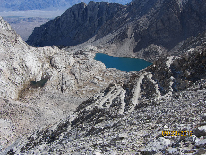
You leave lone pine lake and enter in to Whitney zone here. Beyond this point permits are required and pack out human waste is mandated. Another mile on almost flat trail takes you to a beautiful meadows. Crossing the meadows you enter into outpost camp. This is one place some backpackers like to camp. If you are feel the altitude effects, this is just right place (10300 ft.) to get acclimatized.

Mirror lake is just 1/2 mile from outpost camp, a very picturesque location at 10600ft. However, camping is not allowed in this area.

From here trail is all rocky. You leave the trees below as climb above tree line. So no shade beyond this point. I headed to trail camp for the night. Plan is to summit next morning and return back to trail head by evening. So I can drive back 7 hours to home. Trail camp is located 2 miles from Mirror lake and still 1400 ft to climb. I wanted to plan tomorrow such that I can get down mountains (cross yosemite) before sunset.So I started asking returning hiker on where did they stayed last night and when did they started the summit and when they reached to summit. what I gathered from the hiker was a scary story of last night. It was snowing heavily and winds swept away many tents ( rain flys). 8 groups that stayed at trail camp (groups I spoke with) did not even attempt to summit in the morning. They said that they were so tired dealing with weather last night, so they slept in the morning and climbing down now. Such weather is not strange here; particularly in September. I prepared well for the weather and carried extra guyline to secure my tent. No preparation ever going to be adequate in nature anyway. I met many people who coming from John muir trail as well. They successfully completed summiting and were coming down with victory. John Muir Trail (JMT) starts from Yosemite Valley goes through many vistas and valleies and ends on Whiteney (200+ miles). I met atleast 5 people in this trip those completing their last leg of JMT…a life time achievement… bravo.
I reached Trail camp at 3:30pm. I setup my tent and socialized with fellow campers around.

At 6 PM, while I was enjoying hot coffee by the lake, We heard that a day-hiker at trail creest was seriously ill with altitude sickness. With an hour, we loose light and she is still another hour and half away from where we are and 6 to 7 hours to trail head (if she can walk at regular pace). we all concerned on what to do. I offered to leave my tent and sleeping bag for her and go back. But suggested that it would be better for her to continue to descend to trail head. We all concurred on that. We contacted the group that was assisting her over the radio and informed on what we are thinking. Some people offered electrolite and food. The group descended to trail camp at 8:30pm and continued to trail head. I was concerned a bit as terrian is very rocky for next coouple of miles, but moon came out so strong and illuminated the landscape very bright. So I hope they made it back safely. Next day I asked a ranger on way back and he did not heard anything about them. So news is good news in this case.
Even though I want people get on to these trails and get close to nature, I want to caution about altitude sickness also known as accute mountai sicknes (AMS). Elevation over 8000ft considered as high elevation and some people start to see affects (generally over 10000ft ) like severe headache, nausea and fatigue. The concentration of oxygen remain same at sea level and higher elevation, but due to decreased atmospheric presure, number of oxygen molecules per breath reduce to 50% (approx.). So in order to properly oxygenate the body, your need to breath more. But its difficult to supply same amount of oxygen as low elevations. If your body need more oxygen while walking, it makes situation further worsen. High altitude and lower air pressure causes fluid to leak from the capillaries which can cause fluid build-up in both the lungs and the brain. If any symptoms are observed, its advised to take it easy and wait an hour without any activity. If symptoms persists, its highly advised to climb down. The only reliable way to fight AMS is acclimatization for a day or two at moderate high elevation before assending higher. Listen to your body and act wisely. You should know fail safe situations. Never cross the thin line that separates self-determination and fanaticism. Ranger told me about a fatal case of AMS on Mt. Whitney three weeks ago.
Anyway, I had my dinner and rested in tent for the night. Had no mood for night photography. I carried my camera gear this time as well, but all the pictures except mountains panorama (taken from Alabama Hills) is taken with point and shoot camera only.
Night was quiet, no wind or snow. Two things that can go wrong on these mountains are weather and AMS. Nothing to worry about Sierra bears.
But again, do take right precautions. Bears does not reach 12000 ft. Thunderstorms are very frequent in this area and first sight of thunderstorm, its highly
recommended to climb down. I got up at 4:20AM and started my hike. Moon was still bright. It was pretty cold. I saw couple of headlights already climbing up on trail. From Trail camp its about 5.8 miles, 2500ft elev. to summit.
I regularly climb same elevation and mileage (mission peak) at home about an hour. Mission peak climbs from elevation 200ft to 2400ft elev. in 2.6 miles. It took 4 hours to reach summit. I took two hours to climb 99 switch back and reach to the trail crest. Just in time to watch sunrise.
Switchbacks (actually taken during my descend.
Just couple of minutes before sunrise

It was mesmerizing. Just about a day back, I was frantically searching to shoot alpine glow on these mountains and now I was part of the scenery.
I liked more west side valley with Mt. Hitch cock, Hitch cock and Guitar lakes. Excuse me for poor panorama stitch. I was shooting panoramas using point and shoot (which does not have panorama assistance feature) without tripod. This is the time, I missed my DSLR dearly.


Trail crest is at 13500ft. and 2 miles to the summit. I meet couple of happy faces climb up from west side at John Muir trail junction.
They knew that this the last difficult segment in the journey that endeavored 2 or 3 weeks ago. I heard many stories about how people take wrong trail at this point and go deep into wilderness instead of climbing down the Whitney at right side. I do not figure out, how people can go wrong with such a clear signage at the junction.

I was thrilled at my the first sight of Smithsonian hut on the Summit.

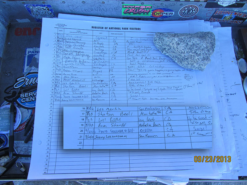
Finally at 8:20AM, I was on the top. Signed the prestigious summit register.
This is for my Dad. His love for forest and decades of public service in forest agencies of India are commendable.
I spent 15 minutes on Summit and started my way back. By 4PM. I was back at my car. It was long day about 12 hours on trail covering 16 miles. Unfortunately, my day wasn’t over yet. I had to driver 7 hours back to home. I was on Tioga pass during sunset. Mountains on Tioga are just decorated with very first snow (on Saturday) and meadows are simmering white with fresh snow. Alpine glow on mountains are so inviting. This is the kind of scenery that I travels miles and miles to photograph…but I have my targets to reach home in time for tomorrow. So I kept driving. Nevertheless, I really enjoyed both Whitney and Tioga pass this time. With last three backpacking trips this summer, I really experienced sierra for first time.
Again and again, I remembered John Muir’s book that read couple of years ago, My First Summer in Sierras.
Snow on Tioga marks, no more backpacking trips for this year (probably). I’m looking forward to take entire 211 miles John Muir Trail next summer (if I can take 3 weeks off).
Happy Clicking
Swamy
